STATE STREET AND CABRILLO BOULEVARD IN SANTA BARBARA - Standing at the foot of Stearns Wharf looking northward turning your head left-to-right on a clear day you get a fantastic view of one of California's most famous places. The jagged rocks sticking out of the dark green mountains of the Los Padres National Forest against the bright blue sky makes for one of the best scenic backdrops in the world. Turning around behind you is the vast blue Pacific Ocean with sailboats making for a beautiful picture, but the picture perfect ocean right off Santa Barbara has a fault, or two. That is to say, there are earthquake faults off the shore of the famed city, and at least one of them were responsible for the 1925 Santa Barbara Earthquake.
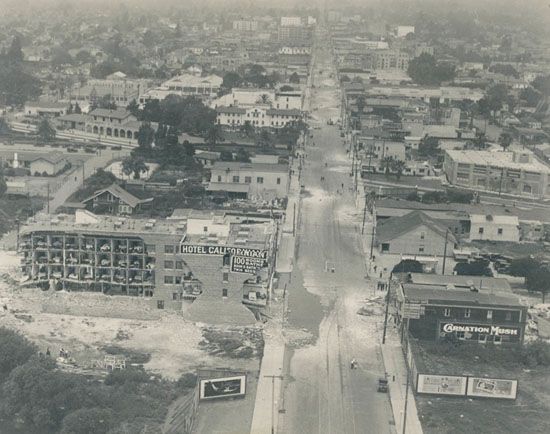
Those asking for a room with a view of the Pacific Ocean at the Hotel Californian perhaps got a little more than what they asked for. This is State Street looking north from Cabrillo Bl. In the almost upper middle-left is the Southern Pacific Depot, which still stands today. Photograph in public domain.
June 29, 2015, will be the 90th anniversary of the Santa Barbara Earthquake, which is one of California's (in)famous earthquakes. Here are six interesting facts about this earthquake.
1- Turns Out The Earthquake Was Much Stronger Than Previous Thought
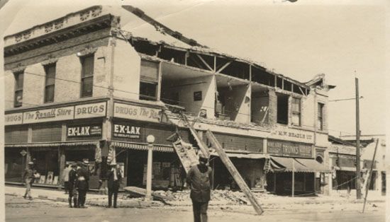
Given the shock and anxiety following the earthquake there probably was not much of a run for the product being advertised on this damaged Rexall Store on State St. Photograph in public domain.
For many decades following the Santa Barbara Earthquake it was believed this earthquake registered magnitude (M) 6.3 on the Richter Scale, which was developed by Doctor Charles Richter about ten years later at The California Institution of Technology, or, as we all know it and look to it after the earth shakes, Cal-Tech in Pasadena. The 1970s brought new developments in better understanding measuring earthquakes. One of those developments was the Moment Magnitude Scale, which is what we used to measure earthquake strength in most California earthquakes today. The Moment Magnitude Scale put the 1925 Santa Barbara Earthquake at M6.8.
2 - The 1925 Earthquake Resulted In The Only Dam Failure In The United States During an Earthquake
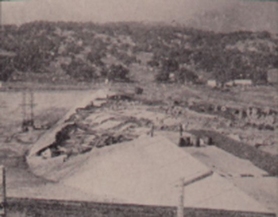
The earthquake damaged Sheffield Dam. Photograph in public domain.
While the Lower Van Norman Dam had severe damage following the 1971 Sylmar Earthquake and came very close to failure (according to the California Geological Survey, had the earth shook for two more seconds in 1971 the dam would have failed flooding a large portion of the San Fernando Valley) the 1925 earthquake resulted in the only dam (so far) to fail as a result of an earthquake in the U.S. The Sheffield Dam, located at the base of the Santa Ynez Mountains at the north-northeast end of Santa Barbara, failed and flooded a good portion of the then sparsely populated eastside of Santa Barbara. According to the University of California-Santa Barbara, "a wall of water rushed between Voluntario and Alisos Streets, carrying trees, automobiles, and three houses with it, and leaving behind it a muddy, debris-strewn mess. The water filled the lower part of town up to two feet deep, until it gradually drained away into the sea." Santa Barbara was still bit of a farm town, and the water swept a lot of cows out to sea. One of the main reasons The Sheffield Dam failed was due to the fact the dam, which held 30 million gallons of water, was built on sandy soil, and sandy soil amplifies ground shaking during a moderate-to-large earthquake with typically devastating results for anything built upon it (see the aftermath of the San Francisco Marina District following the 1989 Loma Prieta Earthquake).
3 - Learning From 1906 Santa Barbara Avoided San Francisco's Fiery Fate
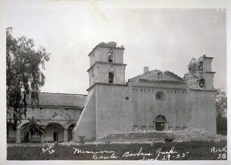
The badly earthquake damaged Santa Barbara Mission. Photograph in public domain.
There was a lot of significant structural damage in this 1925 earthquake, but one thing the aftermath of this earthquake lacked was fires. Many people aware of San Francisco's calamity just less than 20 years earlier realized Santa Barbara could face a similar fate. Thankfully, the overnight operators for Southern California Edison and The Southern California Gas Company immediately shut off their respective utilities to Santa Barbara to help prevent such a catastrophic disaster. Both the Santa Barbara Edison and Gas Company buildings were very badly damaged in the earthquake, but despite the damage William Engle of Edison and Henry Ketz of the Gas Company likely saved Santa Barbara from burning, and were recognized by the city for saving the city by quickly shutting the utilities down.
4 - The Way Santa Barbara Looks Today Is Due To The 1925 Earthquake
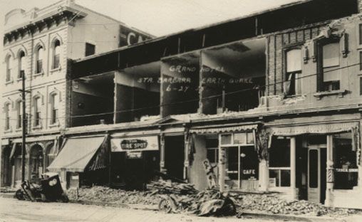
Damage to the Grand Hotel on State St. Photograph in public domain.
Santa Barbara is often rated as one of California's, and even the world's, most beautiful places with its unique architectural style, and that is because of the 1925 earthquake. How so? Well, much of downtown Santa Barbara was destroyed in the earthquake. The Santa Barbara Community Arts Association, which was formed in the early 1920s, was commissioned to rebuild the city, and the association decided upon the Spanish Colonial Revival style, and that decision would soon make the city famous. This in turn resulted in a strict architecture city code that remains in effect to this day. Prior to the earthquake much of downtown Santa Barbara was designed in Neo-Moorish style.
5 - The Epicenter Was In The Ocean
According to the United States Geological Survey (USGS), the earthquake occurred in the Santa Barbara Channel at 6:44 a.m., but the USGS is not too certain just what fault caused the earthquake. What the USGS does believe is this earthquake was the result of slippage on an extension of either the Mesa Fault or the Santa Ynez Fault system. Even though this earthquake had its epicenter in the ocean there was no earthquake generated tsunami (however, some landslides into the ocean caused minor tsunamis).
6 - Rumors Ran Crazy
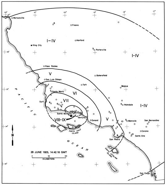
Isoseismal map showing how far and strong the 1925 Santa Barbara Earthquake was felt. Photograph in public domain.
Today, in the immediate aftermath of disasters rumors run crazy, especially amplified in the social media age, and, well, even though there was no social media in 1925 not much has changed since then. Following the earthquake there were rumors in Santa Barbara that Los Angeles and San Francisco had been destroyed, and that this had been the earthquake to end all earthquakes. Once telephone and telegraph service was restored, along with military ships coming up the coast to assist in security of the city, the rumors were quelled as it was quickly noted by The Morning Press, "that the earthquake was purely local." Though the earthquake was "purely local" it was felt from Santa Ana, San Bernardino to Monterey County.
6.8 - Before and After
Before the 1925 earthquake in Santa Barbara the last damaging earthquake in California was in April 1918, in the San Jacinto area with a M6.8 earthquake on the fault that shares the town's name, the San Jacinto Fault (which, by the way, happens to be the most active fault in Southern California). The last notable, damaging earthquake in the Santa Barbara area was in 1978, and that is when a M5.1 shook off the coast of Goleta. That earthquake caused a few shattered windows, knocked a lot of items over and derailed a Southern Pacific freight train.
UPDATE: A Book Coming Out Soon
Turns out the above photographs were not quite in Public Domain as Internet research would suggest, but are apart of a detailed 2010 four-part series of the 1925 earthquake by Neal Graffy in EdHat Santa Barbara, which is a highly recommended read. Furthermore, Mr. Graffy is in the process of writing a book about the earthquake, and will feature how Santa Barbara rebuilt after the shock, and the earthquake faults in and around Santa Barbara.


