(This is an occasional series exploring the many earthquake fault lines in and around Southern California. This series is not intended to be a
scholarly, scientific review of earthquake faults throughout Southern
California, but hopefully will be a jumping off point for you to
understand and further explore the fault lines that cross Southern
California. )
LA HABRA - It has been a weekend of cleaning up shattered glass, having homes assessed and reassessed to see if they are still livable, and dealing with aftershocks in what is turning out to be perhaps the most damaging earthquake in the Los Angeles Basin since the 1994 Northridge Earthquake.
At only magnitude 5.1 it is considered to be a low-end moderate earthquake, but when you get a typical Southern California shallow quake in the magnitude 5 range under an urbanized area that is when you begin to see damage, and that has been painfully proven for residents and businesses in the Fullerton and La Habra area.
The La Habra quake is bringing much needed attention to something rather unpleasant, the Puente Hills Fault, or otherwise called, the Puente Hills Thrust System. (For the rest of this piece we shall just call it the Puente Hills Fault.)
How Unpleasant?
Just how unpleasant is the thought of this fault to geologists, seismologists and emergency planners? Well, a major quake, "The Big One," on the San Andreas Fault in Southern California is going to be a major life altering event, but a major earthquake on the Puente Hills Fault, with an expected magnitude 7.2-7.5, could take such a disastrous event to a whole new level. In fact, a major event on this fault is expected to be worse than a major event on the Newport-Inglewood Fault.
Officials at the United States Geological Survey (USGS) believe this La Habra earthquake was caused by the Puente Hills Fault. It is worth noting USGS also believes the 1987 Whittier-Narrows Earthquake, which seismologists originally thought was on the then newly discovered Elysian Park Fault, was also caused by this fault.
Why So Dangerous?
Using rough directions, the Puente Hills Fault runs about 25 miles, going east-to-west, from about the hills above Brea, across the lower San Gabriel Valley, going northwest into Downtown L.A., and further northwest ending just about before Griffith Park. Seeing and understanding where this fault runs you can understand why a major quake on this fault is such a dreadful thought to officials.
Now unlike, say, the Whittier Fault or Newport-Inglewood Fault, which has noticeable scars in the earth, like hills, the Puente Hills Fault is a blind thrust fault with no surface scars.
A Different Kind of Shaking
One of the many problems with a major earthquake on this fault is, unlike the Newport-Inglewood Fault or even the San Andreas Fault where those faults are vertical faults resulting in intense shaking near where the fault reaches the surface, the Puente Hills Fault is a horizontal fault with intense shaking felt over a much larger area.
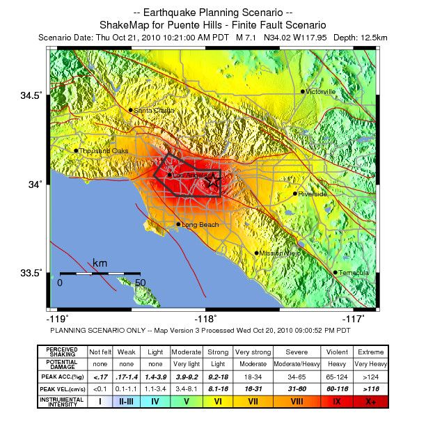
A shake-map scenario of a M7.1 Puente Hills Fault rupture created by the Southern California Seismic Network at the California Institute of Technology (Caltech) in partnership with USGS. No copyright infringement intended; Shown for educational purposes only.
Just How Bad?
The Southern California Earthquake Center (SCEC) along with the University of Southern California conducted a study in 2003 that showed a major earthquake on the Puente Hills Fault could cause "fatalities ranging between 3,000 and 18,000," along with "displaced households ranging from 142,000 to 735,000, with an average of 274,000."
With a fault running from the lower San Gabriel Valley, into Downtown L.A. up to Griffith Park you would have a major earthquake occurring in Southern California's oldest neighborhoods. Seismologists along with emergency planners believe such a quake could result in severe, catastrophic damage to Downtown L.A.'s older, historic buildings along Broadway, Main Street and Grand Avenue.
What about the tall, modern skyscrapers that gives L.A. its modern, worldly skyline?
Thomas H. Jordan, director of the SCEC, told the L.A. Downtown News in March 2011 that, “A 7.5 at Puente Hills would pretty much be a worst-case scenario for Downtown,” with shaking lasting more than a minute. Mr. Jordan says, “It’s conceivable that some of the high-rise buildings would collapse [...] A lot of the modern structures in Downtown are very well constructed, so it would take a very extreme event like [a 7.5] to really cause damage to those very well-constructed buildings.”
A major quake could also have a catastrophic affect on the older industrial neighborhoods just southeast of Downtown L.A.
Of course it needs to be noted that this fault crosses over major freeway and freeway interchanges, along with major railway lines and public transit lines. Chances are good that there will be some kind of damage to these lines in the event of a major earthquake.
Some may remember during the Northridge Earthquake railroad tracks actually bent in a few areas.
Of course, there are the fires that will likely break out, and the water-pipes that will burst.
One of the most dreadful worst case scenarios is a major earthquake occurring during the Santa Ana Winds.
The study predicts total damage cost may come to $250 billion.
While a lot of the focus involving a major earthquake on the Puente Hills Fault has been focused on L.A. it is expected that Orange County will have severe damage with strong ground shaking expected in north Orange County. The M5.1 La Habra earthquake was hardly a dress rehearsal for what is expected in Orange County.
YouTube video created by USGS, SCEC and San Diego Super Computer Center showing the shaking expected from a major Puente Hills Fault earthquake. No copyright infringement intended; shown for educational purposes only.
Not to be left out the Inland Empire is expected to receive strong shaking and some severe damage, particularly in southwestern San Bernardino County.
So, all around when you get right down to it just how bad will a major Puente Hills Fault earthquake be? Well, there is only really one way to find out, and that is when Mother Nature decides to show us.
When Will Mother Nature Decide To Let Us Know?
Well, according to USGS researcher Ned Field, the lead author of the SCEC-USC study, a major rupture on the Puente Hills Fault occurs about once every 3,000 years. "In fact," says Mr. Field in the study, "as an individual your odds of dying of a heart attack or an auto accident are much greater than dying from this earthquake."
If you are like most Southern Californians chances are when you hear that number you probably think there is not anything to worry about, because 3,000 years is a long way away. Well, here is the bad news, geologists and seismologists are not too sure where they are at in the cycle, such as if we are maybe 2,800 years away from the fault rupturing, or one month away from the fault rupturing.
Aside from knowing when the fault ruptures the SCEC-USC study found that the Puente Hills Fault has ruptured at least four times in the last 11,000 years, with earthquakes with magnitudes ranging from 7.2 to 7.5.
It should be clear by now even if the next major rupture is a couple thousand years away the Puente Hills Fault is going to cause some problems for us in the years to come.
It is worth noting that in the same March 2011 L.A. Downtown News story Mr. Jordan points out the San Andreas Fault is still a bigger threat to the area, because earthquakes there happen about every 100 to 200 years.
The last major San Andreas' rupture in our area was the M7.9 1857 Fort Tejon Earthquake, which rupture along 225 miles of the San Andreas Fault beginning near Parkfield and rupturing south to the Cajon Pass.
The last major southern rupture of the San Andreas Fault between the Cajon Pass and the Salton Sea is believed to have occurred around 1690.
Why Does It Seem Like I Am Only Hearing About This Fault Now?
With such a dangerous fault running through Downtown L.A. you think you would of heard all about the Puente Hills Fault growing up or living in Southern California for many years. After all, at one point we have heard all about the San Andreas Fault, Newport-Inglewood Fault, Hollywood Fault, San Jacinto Fault, and Whittier Fault, among many others, but it seems like there has not been a lot said about this extraordinarily dangerous fault.
You are not alone in thinking and believing you have only recently heard about the Puente Hills Fault, because it was just barely discovered in 1999, and it has taken a few years after that for officials to really understand the danger it poses.
In the aftermath of the Northridge quake there was urgency among geologists and seismologists to attempt to find blind faults around Southern California.
So Do All These Recent Quakes Mean We're Going To Have a Big Quake?
The recent earthquakes in Orange County and L.A., along with the January 15 M4.4 shaker in Fontana, may simply mean, according to USGS, that Southern California is coming out of its "earthquake drought."
As Doctor Lucy Jones from USGS has pointed out many times in various media interviews, following the aftermath of the 1994 Northridge Earthquake the L.A. area, aside from the little jolt here and there, has been very seismologically quiet. It seems possible the 1992 Landers/Big Bear earthquakes along with the Northridge quake may have relieved stress for a time in Southern California, but now we may be reentering a seismologically active period in Southern California.
It Could Happen Anytime!
Whether it is preceded by a series of noticeable earthquakes, or no quakes at all, a major earthquake can occur anytime in Southern California.
We all want a direct answer to the unknowable, and that is WHEN is a major earthquake going to happen? The direct answer to that is this, at this time there is no accurate way to predict earthquakes, and thus there is no way of knowing when a major earthquake is going to occur.
Just Be Prepared!
For a lot of people the above answer is not the one they want to hear, but it is the only answer available. So, all we can do is prepare and have a plan in place when it does happen.
Resources To Help You Prepare
Prepare SoCal from The American Red Cross
Ready L.A. - City of L.A. Emergency Preparedness
Los Angeles County - Emergency Preparedness
Ready O.C. - Orange County Emergency Preparedness
San Bernardino County - Emergency Preparedness
Riverside County Fire Department - Emergency Management
Ready Ventura County - Emergency Management
San Diego County - Emergency Preparedness
Cal-OES - California Governor's Office of Emergency Services
Tips on Preparing an Emergency Kit from Ready.Gov


