Showing posts with label San Andreas Fault. Show all posts

Monday, June 29, 2015

Seven Facts About The Landers Earthquake

THE HOT MOJAVE DESERT IN SAN BERNARDINO COUNTY - Little earthquakes, many of them very little earthquakes, shake Southern California everyday. However, it was on June 28, 1992, on which the largest county in the lower 48 states was the epicenter of the largest earthquake in California in about 40 years. Though not a lot of spectacular, memorable damage was done, there were a lot of lessons learned from this earthquake.

 photo 640px-Landers_quake_bowling_alley.jpg
Probably the most noticeable damage following the 1992 earthquake was this bowling alley in Yucca Valley. Photograph taken by the National Oceanic and Atmospheric Administration and in public domain.

Waking Southern California up on a Sunday morning at 4:57 a.m. in the very busy year of 1992 here are seven interesting facts about the earthquake commonly known as, "The Landers Earthquake."

1 - It Still Remains The Last Largest Earthquake In California

It has been over 20 years and the Landers Earthquake was, according to the moment magnitude scale (M), a M7.3 earthquake, and (as of this writing) retains the record as being the last large earthquake, by way of magnitude, to hit California. Prior to the 1992 event the last large earthquake to hit California was the 1952 Kern County Earthquake, which occurred near Wheeler Ridge on the (thought to have been inactive) White Wolf Fault, and was M7.3. After the Landers Earthquake the next closest earthquake in magnitude size was the 1999 Hector Mine Earthquake at M7.1.

Even though this earthquake was rather big, it was not "The Big One." In fact, "The Big One" is expected to be M7.8-8.0.

As paleoseismology has shown this record held by the Landers Earthquake will likely be broken at some point.

2 - There Was A Lot Of Fault Involved

Rather, lot of faults were involved. The Landers Earthquake did not just rupture on one single fault-line, but rather ruptured on five separate fault-lines: Johnson Valley, Landers, Homestead Valley, Emerson, and Camp Rock Faults, according to the Southern California Earthquake Data Center (SCEDC).

3 - A New San Andreas Fault Could Be Opening Up

That is the theory, at least, from Lawrence Berkeley National Laboratory (LBL) geologist Pat Williams. According to the LBL article that came out in August 1992:

A theory that was posed in the aftermath of last month's earthquakes was that a new San Andreas fault could be opening up from the Salton Sea north to central California. Williams says instead that the recent activity has linked the Gulf of California with slip systems east of Mount Whitney, the 1872 site of one of California's three historic magnitude 8.0 earthquakes.

Williams' theory is that the strain is heading toward the back side of the Sierras, northeast into central Nevada, where it may affect active geothermal fields. The earth's movement could enhance the production of geothermal fluids by contributing to a thinning of the crust and allowing the fluids to circulate through complex fractures.

A huge strain response on a scale never seen before occurred during the 24 hours following the Landers earthquake. At the Pinion Flats Observatory researchers from UC San Diego observed a massive redistribution of strain deep in the earth's crust. For the first time, Williams says, scientists will be able to study not just how the upper 12 kilometers of brittle crust reacts, but the response of the deep crust beneath it.

This theory is still being debated among geological and seismologists circles, and, frankly, it will probably take a few more large earthquakes to see if this theory is correct. The earth sciences is sometimes a game of wait and see.

4 - Did You Feel The Foreshock?

At the time nobody knew it was a foreshock to the Landers Earthquake, and in fact, there was concern this might have been a foreshock to a San Andreas Fault event, and that was a M6.1 foreshock that hit about 11 miles east of Desert Hot Springs on April 23, 1992. The Earth Day earthquake caused a moderate amount of property damage in the Palm Springs area. As this earthquake, called the Joshua Tree Earthquake, rolled through to Los Angeles at 9:50 p.m. a Dodgers' game was going on and Vin Scully broadcast the the rolling motion happenings at Chavez Ravine.

There was concern this could be a foreshock to a San Andreas' event, and, according to the SCEDC, "A San Andreas Hazard Level B was declared following this quake, meaning that a 5 to 25% chance existed for an even larger earthquake happening along the San Andreas fault within 3 days."

This made for some big headlines in L.A. media, but by April 29, 1992, this earthquake and the threat of the San Andreas Fault unleashing its fury would be forgotten, at least for a little while.

This foreshock had its own foreshock, a M4.6, a little over two hours earlier.

5 - Was The Big Bear Earthquake Really An Aftershock?


This was the Big Bear Earthquake broadcast live on CNN to the country and parts of the world.

The short answer, no.


This is a report of the earthquakes from KTVU-TV, Oakland/San Francisco, which includes on-air coverage from KTTV-TV as the Big Bear Earthquake shook the KTTV/Fox 11 newsroom at the now gone Metromedia Square in Hollywood.

At 8:05 a.m. on that Sunday morning a lot of people were already up and had already felt quite a few aftershocks, but one the largest, and probably most damaging, earthquake that morning was the Big Bear Earthquake. It was originally thought the M6.5 Big Bear Earthquake was simply an aftershock, and having an aftershock of that size following such a large earthquake is not unusual. However, as later research showed, the Big Bear event was not an aftershock of the Landers Earthquake. Rather, that earthquake in the San Bernardino Mountains was apart of a "regional earthquake sequence," according to the United States Geological Survey (USGS).

6 - Location And Magnitude

 photo 510px-USGS_ShakeMap_-_1992_Landers_earthquake.jpg
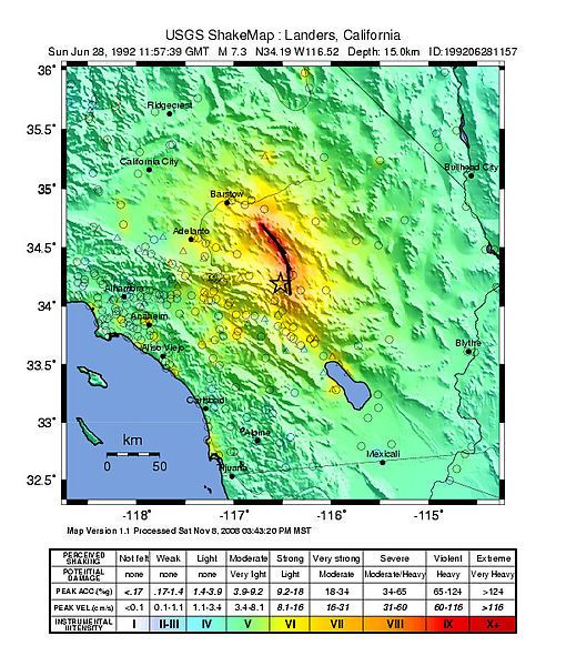
While there was some strong shaking in the Inland Empire, L.A. area, Orange County and San Diego area, all of the violent shaking, which causes severe damage, was in mostly unpopulated areas of the San Bernardino County desert. "Shakemap" by USGS and in public domain.

Even though the Landers Earthquake was a historically large, powerful earthquake, the epicenter was seemingly in "the middle of nowhere," and damage was mostly minor-to-moderate (if you were somebody who lived near the epicenter in "the middle of nowhere" it was, no doubt, not quite a good morning). The Big Bear Earthquake a little over three hours later, and a lot less powerful than the Landers' event, was in a more populated area, and thus more damage was caused despite it only being a moderate-size earthquake. The Northridge Earthquake vividly showed that it only takes a moderate-sized earthquake in an urban area to cause major damage. So, even though an earthquake may be quite large (and scary sounding to those around the country who only hear, "A 7.3 earthquake struck the L.A. area on Sunday morning"), if it is located in a very sparsely populated area very little property damage will be found. This, too, would be visibly illustrated following the 1999 Hector Mine Earthquake.

7 - The Landers Earthquake Happened One Year After The Sierra Madre Earthquake

Some people have forgotten about this earthquake, but on June 28, 1991, a M5.8 earthquake struck in the Angeles National Forest about 12 miles northeast of Pasadena in an event called, The Sierra Madre Earthquake. It is interesting and curious that some people have forgotten this event as this earthquake caused some major property damage in the Pasadena area, such as, windows shattering and brick-walls collapsing. One of this interesting things about this earthquake was for a quake of its size it had a small aftershock sequence.

No, despite these earthquakes occurring a year apart they are not related.


Friday, April 17, 2015

A Shaky Myth

ANAHEIM - Over the last few weeks there have been some minor earthquakes in the Los Angeles area. These minor shakers have wiggled the ground just enough to get a lot of people's attention, and making a lot of people wonder what all this shaking may be about. On Sunday, April 12, there was a magnitude (M) 3.3 shaker in the West L.A. area that appears to be on the Newport-Inglewood Fault, on Wednesday, April 15, there was a M3.1 in the Sylmar area, and on Saturday, April 2, there were several minor earthquakes in the Newhall Pass area with the largest quake being M3.2.

 photo Kinemetrics_seismograph.jpg
Kinemetrics seismograph used by United States Department of the Interior. Photograph used under Creative Commons license.

If you grew up in Southern California, or even Japan, or really anywhere in the world that is considered "earthquake country," you probably have heard immense myths about earthquakes.

Is There Anything To These Earthquake Myths?

The short answer: NO! We all want an answer to the unknowable, especially if it is something that can greatly impact our lives and, frankly, our way of life, within just a few seconds, but at this time there is no scientific data and proof to accurately and precisely predict when a big earthquake will occur. With decades filled with tons of scientific studies, myths about earthquakes have been proven to be just that, myths.

Dolphins and Whales On The Beach

In recent weeks there has been a story floating around that several beached dolphins off the coast of Japan means a big earthquake is going to happen, because this happened once before off the Japan coast days before the great 2011 Japan earthquake. Furthermore, this, the sudden beaching of dolphins and whales, has also happened before large earthquakes in New Zealand and Chile.

Well, the beaching of dolphins and whales has happened in many other places many times before, and there has been no large earthquake in the following days. Thus, there has been no conclusive evidence that beaching of these great sea animals mean a big earthquake is imminent.

Full Moon Pulling The Gravity

Another very common myth is large earthquakes occur when there is a full Moon due to the Moon's gravity pull on earth. Well, out of all these earthquake myths this one has some truth to it as scientists at the United States Geological Survey have, "found a correlation between earth tides (caused by the position of the moon relative to the earth) and some types of earthquakes."

However, please understand that earthquakes can and do happen whether or not the Moon is shining bright in the sky, and thus the Moon is NOT a viable way to predict earthquakes.

Big Shakes Only In The Morning

If you grew up in Southern California you probably remember all too well that our most "memorable" earthquakes occurred early in the morning, which has lead a lot of people to believe only big earthquakes will only happen in the morning. This is a very big myth. The fact that major earthquakes have occurred in Southern California in the morning hours is simply a roll of the dice when Mother Nature has decided to give us a big shake. That is a way of saying it simply is by pure chance that large earthquakes have happened in the morning and there is no scientific proof that significant earthquakes occur in Southern California only in the morning hours. In fact, the 1933 Long Beach Earthquake happened at 5:55 p.m. Bottom line, "The Big One," or the next big enough one, can happen at 4:31 in the morning, or 4:31 in the afternoon.

Earthquake Weather

Probably one of the biggest myths in Southern California is so-called "earthquake weather." The common belief in Southern California is when it suddenly warms up earthquakes will happen. Well, many studies have shown when the earth decides to shake it gives no thought to the weather. After all, there have been major earthquakes in Southern California on Christmas Day and in the middle of summer.

Animals Know When An Earthquake Is About To Happen

Many people have said that right before an earthquake their pet, typically a dog or cat, "acted weird" or suddenly began running about without any reason. In most cases what animals are sensing are the P-Waves of an earthquake, which can be detected by sensitive animals, and sometimes sensitive humans. There have been cases where people report animals acting "weird" a few days before an earthquake. Plenty of studies have been done on this subject, and studies in China in the 1970s thought there might have been a breakthrough with animals helping predict earthquakes. Well, like many studies of possible earthquake precursors and predictions, observing animals has proven to be inconclusive, and thus animals cannot predict earthquakes.

What About Earthquakes Being Predicted To Happen In 20 Years

When geologists and seismologists talk about an earthquake happening either in a certain region or on a certain earthquake fault-line what they are doing is forecasting, not predicting. The words forecast and prediction are sometimes used interchangeably, but they have very different meanings when it comes to seismology. When it comes to earthquakes seismologists, for example, look at the history of a fault-line and how often it has produced a major earthquake, otherwise called paleoseismology. If, for example, a fault-line has produced a major earthquake on average every 100 years and it has been 70 years since the said fault-line last rupture seismologists will forecast the fault-line will produce a major earthquake within the next 30 years. Ostensibly, using our example, if it has been, say, 120 years since the last major earthquake on said fault-line you will hear that we are overdue for a major earthquake.

Caution In Earthquake Forecasting

While paleoseismology has been one of the best breakthroughs in figuring out how often a certain fault-line ruptures it must be stressed that while the average rupture may be, for example, every 100 years, it has also showed what could be best described as anomalies. That is to say even though the fault-line is suppose to cause a major earthquake on average around every 100 years sometimes, as paleoseismology shows, the said fault-line may of had a period in the past where it did not have a major earthquake for 200 or even 300 years.

On the other end, paleoseismology has showed major earthquakes on the studied fault-line, using our example, have occurred less than 100 years apart.

Think of it this way, you know how on the seven-day weather forecast on the seventh day they say a major storm is coming based on all the information on the way the storm pattern is shaping up, and come that seventh day the storm is nowhere to be found and it is very sunny outside. Well, long-term earthquake forecasting is kind of like long-term weather forecasting. Everything is lined up and based on all evidence it looks like an event should happened and thus is forecast to happen, like a big rain storm or big earthquake, but it just fails to happen.

Will There Ever Be Day Where We Can Predict Earthquakes?

Well, never say "never," but in general when it comes to earthquake prediction the geologist and seismologist community has kind of moved on to long-range earthquake forecasting, such as more paleoseismology studies, and developing and funding earthquake early warning systems.

It is very important to understand that the study of earthquakes is an extraordinarily young science and even when major earthquakes have occurred scientists have learned something new. After all, it was the 1994 Northridge Earthquake that showed how dangerous blind thrust faults are to the L.A. area and gave way to more studies of such faults like, The Puente Hills Thrust Fault.

Even though the earth science community in general is moving away from precise earthquake prediction please have no fear, because many professional, retired, government, amateur and wanna-be geologists and seismologists are still looking for that Holy Grail of trying to solve that puzzle of accurately predicting earthquakes.

So, The Bottom Line Is The One Thing Nobody Wants To Hear...

Even with all the marvelous advances in technology there is still no accurate way to predict when precisely a major earthquake will occur. It could happen one minute from now, or another 20 years, or even another 100 years from today. All you can do is prepare.

Friday, March 6, 2015

Five Odd Southern California Earthquake Facts

HOLLYWOOD - Looking up Vine Street from Hollywood Boulevard the sudden rise of the street just above Yucca St. on the hill where The Hollywood Freeway lays atop shows the not so subtle signs of The Hollywood Fault, which has been in the news lately. Recent mapping by the California Geological Survey shows the fault is what helps give Hollywood and Los Feliz its character with its hills, and while the beauty is nice some developers are none too happy with this study.

When The Hollywood Fault, or any Southern California fault, will rupture with fury again is not clear as there are no accurate ways to predict earthquakes (not to be confused with forecasting earthquakes).

Walking over and along The Hollywood Fault on Los Feliz Blvd. one wonders about earthquakes past, and thus this piece is not about unhappy developers not getting their way, or even so much The Hollywood Fault, but rather five odd, peculiar Southern California earthquake facts.

 photo CAoverpass1971.jpg
Severe freeway damage following the 1971 Sylmar Earthquake. Used under a Creative Commons license.

1 - The First Earthquake on Record

For thousands and thousands of years earthquakes, both very small and very large, have been happening in Southern California, as paleoseismology has proven, but while there were many animals and trees to feel the shaking as hills and mountains were being pushed up there were hardly many humans around. Any humans that were around never kept anything written about it, or hid their diary.

It would not be until 1769 that the first earthquake in Southern California would be recorded. Gaspar de Portola, Father Juan CrespĂ­ and a group of over 60 explorers from Spain, in the name to extend Spain's control up the Pacific Coast and establish colonies and missions (and hopefully prevent Russia and England from acquiring and taking this territory), set out from San Diego to Monterey on July 14, 1769. Maps at the time available to de Portola's group showed California extending from San Diego only to the Monterey Bay.

 photo Map_of_California_as_an_island_R.W._Seale_1745.jpg
When California was still thought of as an island in this 1745 map of California, and so not unusual to think de Portola's group thought the soon-to-be Golden State went as far as Monterey. Used under Creative Commons license.

After about a couple weeks of walking from San Diego to current day Orange County on July 28, 1769 and setting up camp at what is now The Santa Ana River in Anaheim de Portola's group felt a very large earthquake.

This earthquake occurred around 4 p.m., and the explorers recorded many aftershocks, several of them strong, as they made their way into the San Gabriel Valley. Records kept by de Portola's group show they stopped feeling any earthquakes when they were exiting the San Fernando Valley.

Among geologists, seismologists and historians there is much debate on just how big this earthquake was and just where the epicenter was located. Given the records by the de Portola team it was believed by many in the science and historic communities this earthquake was around magnitude 6.0 and probably on The San Jacinto Fault in the Inland Empire. Part of this was based on the diaries of the de Portola team saying they felt no more earthquakes once exiting the San Fernando Valley.

The United States Geological Survey (USGS) officially lists this earthquake, the very first earthquake in a long, forever growing list of Southern California earthquakes cataloged by the USGS, as M6.0 in the Los Angeles Basin. 

The when and where of this first recorded Southern California earthquake by the USGS has been challenged by University of California-Irvine geology professor Lisa Grant. Ms. Grant has proposed that the 1769 earthquake was actually M7.3 located on the relatively unknown San Joaquin Hills Fault located between Newport Beach and Laguna Beach, which resulted in the Orange County coastline being raised by almost 11 feet.


Put together by The Southern California Earthquake Center here is a scenario of a M6.7 earthquake on The San Joaquin Hills Fault.

The video above, combined with the diaries kept by the de Portola team, shows the theory by the UCI professor to be possible as strong shaking wanes in The San Fernando Valley. One thing the debate of the 1769 earthquake has brought up is the fact that Orange County has a major earthquake fault line that is not really well known, which has brought on more studies of the fault.

The when and where of this very first recorded Southern California earthquake still fascinates geologists and seismologists. Among other reasons, figuring out the mystery of this earthquake may help further understand and clarify the nature of earthquakes in Southern California (like the existence of a major earthquake fault in Orange County).

2 - Last Large Earthquake on Record

The last large earthquake in Southern California was a M7.9 in 1857, which is commonly called The Fort Tejon Earthquake. Not only was this the largest earthquake in Southern California recorded history, but this was one the largest earthquakes ever recorded in the United States.

This was also the last time The San Andreas Fault had a major rupture in Southern California. The infamous fault line is believed to have ruptured near Parkfield and continued rupturing south to just near The Cajon Pass. In fact, this was the last time "The Big One" happened in Southern California.

Southern California was nowhere near the megalopolis it is today, and so damage was limited to scars in the Earth. There were many scares in the Earth with cracks reported in the San Gabriel Valley and in the San Bernardino area.

In some areas the shaking is believed to have lasted up to, and even over three minutes. In Downtown L.A. the shaking is believed to have lasted over a minute.

Both the USGS and disaster planners fear the impact a repeat of this earthquake would have today.

The last time the lower southern segment of the San Andreas Fault between San Bernardino to the Salton Sea ruptured is believed to have been in or around 1690.

3 - Deadliest Earthquake Ever

The earthquake was only M6.4, but the deadliest earthquake in Southern California was the March 1933 Long Beach Earthquake, which killed 120 people. Much of the death was due to the brick construction of many buildings in Long Beach and Compton.

 photo Compton.jpg
Compton in the aftermath of the 1933 earthquake. The fallen bricks are what killed many people in this earthquake. Used under a Creative Commons license.

Many schools were badly damaged, but luckily school was out when the earthquake struck at 5:55 p.m. (which should break the myth that big earthquakes only happen in the morning). Had this earthquake occurred just a few hours earlier the death toll would have been much higher with many school children killed.

This thought disturbed and worried a lot of people, and very quickly in April 1933 the state passed The Field Act that mandated earthquake resistant construction for schools.

 photo old_thomas_jefferson_jh.gif
Jefferson Junior High School in Long Beach after the quake. Damage to schools like this throughout the area and what could have been worried parents, teachers and students alike, which led to the passage of The Field Act. Used under a Creative Commons license.

In the 1971 Sylmar Earthquake schools built after The Field Act made it through with no damage while schools built before 1933 suffered major damage.


A newsreel showing the aftermath of the 1933 earthquake.

4 - The 1933 Epicenter Was NOT in Long Beach

The deadly jolt in 1933 will forever be known as The Long Beach Earthquake, but the epicenter was not in Long Beach. Rather, the epicenter was in Newport Beach on The Newport-Inglewood Fault.

While the damage was bad in Long Beach t
he earthquake ended up being the most damaging and deadliest earthquake in Orange County history. Most of the death and destruction was in Santa Ana. However there was also major damage in Garden Grove and Anaheim.

 photo 1933longbeachP061.jpg
Very badly damaged building in Santa Ana. Used under Creative Commons license.

Damage was so bad in downtown Santa Ana that the Santa Ana Register, which was located in downtown Santa Ana, put together their newspaper working outside of their damaged building.
 

Of course this would not be the first time an epicenter would be misidentified. The Sylmar Earthquake was not in Sylmar, but the hills above Sylmar. The Northridge Earthquake was not in Northridge, but in Reseda.

5 - The Christmas Day Earthquake

If you were asleep on Christmas morning in 1899 and felt the house shake you may have thought it was Santa Claus stuck in your chimney trying to wiggle his way out. It was not Santa, but Mother Nature showing that even big earthquakes do not get the holiday off.

At 4:25 a.m. a M6.5 earthquake stuck near San Jacinto on the fault of the same name, The San Jacinto Fault.

This earthquake was felt in a very wide area waking people up in Los Angeles, San Diego and as far as Santa Barbara.

Damage was greatest in San Jacinto and Hemet with many collapsed buildings. In Riverside many chimneys were knocked down and cracks in many buildings appeared. In fact, throughout much of the then sparsely populated Inland Empire the damage reports were much the same along with shattered windows.

The earthquake was deadly at the nearby Soboba Indian Reservation, where six people were killed by falling adobe walls.

In the Earth sciences community there is a little bit of debate if whether this earthquake was larger than M6.5 and just where exactly the epicenter was located. The Southern California Earthquake Center believes the epicenter may have been ten miles south of San Jacinto.

In the end, whether an earthquake hits on Christmas morning or during an imperialistic exploration journey, it is extraordinarily important to be prepared for the next big earthquake.


Tuesday, January 13, 2015

Those Southern California Earthquakes

CAJON PASS - ONE PLACE WHERE THE PACIFIC PLATE AND NORTH AMERICAN PLATE MEET - Even if you are not the biggest newshound you know Worldwide 2014 was not a very good year, but in our place of the World known as Southern California it sure seemed like things were shaking more than usual.


 photo SAF.jpg
One of the many places in Southern California where the infamous San Andreas Fault runs. Shown for educational purposes only; no copyright infringement intended. Used under a Creative Commons license.

In 2014 several widely "feel-able" minor-to-moderate earthquakes rattled the Los Angeles Basin. The most notable earthquake was the magnitude 5.1 (M5.1) La Habra Earthquake, which was the most damaging earthquake in the area since 2008.

In fact, things have been relatively quiet since the aftermath of the 1994 Northridge Earthquake, but in the last year it seems like things, seismically speaking, have been picking up.

So what gives? Well, as many geologists and seismologists at the United States Geological Survey note, such as "L.A. Earthquake Czar" Doctor Lucy Jones, things are just getting back to normal. In fact, having M4 and M5 earthquakes in Southern California is the normal way of life and we should be having a few them yearly. The problem for some people is that within the 20 years since the Northridge Earthquake many people have moved to Southern California, or been born in the last 20 years and may never had known of a time when these types of earthquakes rattled Southern California on a regular basis (of course they are many others who have been here well beyond 20 years and probably choose to forget we live in earthquake country).

Wait, These Types of Earthquakes Used To Happen All The Time?

Yes, and, by way of The Southern California Earthquake Data Center, here is a list of notable Southern California earthquakes between 1986 and 1994.

July 8, 1986 - North Palm Springs - M5.6
July 13, 1986 - About 32 miles West-Northwest offshore of Oceanside - M5.4
October 1, 1987 - Whittier Earthquake - M5.9
November 23, 1987 - Near Salton Sea and about 90 miles east of San Diego - M6.2
November 24, 1987 - About the same location as above - M6.6
June 26, 1988 - Upland - M4.7
December 3, 1988 - Pasadena - M5.0
January 18, 1989 - Malibu - M5.0
April 7, 1989 - Newport Beach - M4.7
June 12, 1989 - Montebello - M4.9
February 28, 1990 - Upland - M5.4
June 28, 1991 - Sierra Madre - M5.8
April 22, 1992 - Joshua Tree - M6.1
June 28, 1992 - Landers Earthquake - M7.3
June 28, 1992 - Big Bear - M6.4
January 17, 1994 - Northridge Earthquake - M6.7
   
What Happened After 1994?

Well, while there were the always ongoing minor M1-M3 jolts in the region and some M4 earthquakes just outside the area in the desert, along with a series of M5 earthquakes in rural Kern County in 1995-96 (some of which were felt in the L.A. area), notable earthquakes in and around the L.A. basin and Southern California in the aftermath of the Northridge Earthquake had became far, few and in-between.

In fact, outside of large Northridge aftershocks, which mostly faded by 1995, the next noteworthy earthquake would be the 2001 M4.2 West Hollywood Earthquake.

Furthermore, while there was a M5.4 in Big Bear in 2003 it would not be until 2008 that the L.A. basin would experience a damaging M5+ quake, the 2008 M5.4 Chino Hills Earthquake. That is about 14 years since a M5+ earthquake struck the L.A. area.

It is noteworthy to point out on October 16, 1999 in the rural San Bernardino County desert there was a M7.1 earthquake that shook most of Southern California, known as the Hector Mine Earthquake. This earthquake had an epicenter in such a rural area there was very little damage, but it did cause power outages in the Inland Empire, L.A. and Orange County. Despite such a significant earthquake it has been mostly forgotten.
  
Why Did The Lull In Earthquakes Happen?

Simply put, geologists and seismologists believe the Landers and Northridge Earthquakes relieved stress for a time on the fault-lines in Southern California.

In geological time 20 years is less than a blink of an eye.

So, Are We Coming Out of The Earthquake Lull?

Earthquakes in the last couple years would seem to say, "yes," and, much more importantly, in many interviews with the media after some of these shakers Dr. Jones believes we are going back to our normal pattern of earthquakes.

Does This Mean The Big One (Or A Big Enough One) Is Going To Happen?

Who knows?

It could mean something, or it could mean nothing, which is a way of saying there is no way to predict earthquakes.

Or, put another way, a damaging earthquake could happen tomorrow night, or ten years from now.

We Keep Hearing About The Threat of A Big Earthquake Happening, But Will It Ever Really Happen, Or Is It Just Hype?

Recent Southern California earthquake data listed above, along with historic earthquake data and studies going back hundreds of years show that a really big earthquake, or big enough earthquake to cause damage, will hit Southern California again, and again, and again, at some point.

What is most important to understand is Southern California, and much of California for that matter, sits atop two tectonic plate boundaries, the Pacific Plate and North American Plate. Those two plate boundaries in our part of the World create what is known as a transform boundary where the two plates slide past each other.
 photo 640px-Plates_tect2_en.png
Image of plate tectonics by USGS via Wikimedia Commons, Creative Commons License.

In California the San Andreas Fault forms the tectonic boundary between the Pacific Plate and the North American Plate, and, simply put, as these boundaries slide past each other many times they become stuck, pressure builds up and you have an earthquake.

Will The Plates Ever Stop Moving Against Each Other So We Can Stop Having Earthquakes?

Nope!

As long as the World is spinning the plates will keep moving, and thus Southern California will continue to always have earthquakes big and small.

When Was The Last Great Big Earthquake in Southern California?

While there certainly have been many "big enough earthquakes" in our lifetime the last great big earthquake in Southern California was in 1857, commonly called The Fort Tejon Earthquake.

This earthquake was on the San Andreas Fault, which many in the Earth science community believe the infamous fault ruptured from the Parkfield area southward to the Cajon Pass. One reason that lead to this belief is the surface rupture along the fault was about 230 miles.

This earthquake is believed to have been M7.9, one of the strongest earthquakes ever recorded in North America, but California was a very sparsely populated place, and so damage and casualties were very limited.

It is believed shaking in Southern California lasted up to three minutes.

A similar earthquake today would profoundly impact Southern California with damage and economic loss going easily into the billions of dollars, according to SCEDC

What About The Other Section of The San Andreas Fault?

There is another section of The San Andreas Fault that runs through Southern California, and that section runs between San Bernardino to the fault's terminus in the Salton Sea.

Recent studies have shown the last time this section ruptured was in or around 1690.

For some geologists and seismologists it is this section of The San Andreas Fault they believe will bring us the dreaded Big One.


Video developed by Dr. Robert Graves of the USGS showing a simulation of a major southern San Andreas Fault earthquake. No copyright infringement intended; shown for educational purposes only. 
 
Just Be Prepared!

All you can do is prepare and be prepared

There is no way at this time to predict earthquakes. The only earthquakes that can be predicted are aftershocks.

Making The Best of The Faults Below Our Feet 

One way to make the best of all these fault-lines around us is to enjoy the natural beauty they have produced. After all, what gives Southern California its dramatic mountains and hills are earthquakes, and if we did not have earthquakes we would probably be as flat as Kansas.


Sunday, March 30, 2014

Know Your Faults: Puente Hills Fault

(This is an occasional series exploring the many earthquake fault lines in and around Southern California. This series is not intended to be a scholarly, scientific review of earthquake faults throughout Southern California, but hopefully will be a jumping off point for you to understand and further explore the fault lines that cross Southern California. )   

LA HABRA - It has been a weekend of cleaning up shattered glass, having homes assessed and reassessed to see if they are still livable, and dealing with aftershocks in what is turning out to be perhaps the most damaging earthquake in the Los Angeles Basin since the 1994 Northridge Earthquake.

At only magnitude 5.1 it is considered to be a low-end moderate earthquake, but when you get a typical Southern California shallow quake in the magnitude 5 range under an urbanized area that is when you begin to see damage, and that has been painfully proven for residents and businesses in the Fullerton and La Habra area.

The La Habra quake is bringing much needed attention to something rather unpleasant, the Puente Hills Fault, or otherwise called, the Puente Hills Thrust System.  (For the rest of this piece we shall just call it the Puente Hills Fault.)

How Unpleasant?

Just how unpleasant is the thought of this fault to geologists, seismologists and emergency planners? Well, a major quake, "The Big One," on the San Andreas Fault in Southern California is going to be a major life altering event, but a major earthquake on the Puente Hills Fault, with an expected magnitude 7.2-7.5, could take such a disastrous event to a whole new level. In fact, a major event on this fault is expected to be worse than a major event on the Newport-Inglewood Fault.

Officials at the United States Geological Survey (USGS) believe this La Habra earthquake was caused by the Puente Hills Fault. It is worth noting USGS also believes the 1987 Whittier-Narrows Earthquake, which seismologists originally thought was on the then newly discovered Elysian Park Fault, was also caused by this fault.

Why So Dangerous?

Using rough directions,
the Puente Hills Fault runs about 25 miles, going east-to-west, from about the hills above Brea, across the lower San Gabriel Valley, going northwest into Downtown L.A., and further northwest ending just about before Griffith Park. Seeing and understanding where this fault runs you can understand why a major quake on this fault is such a dreadful thought to officials. 

Now unlike, say, the Whittier Fault or Newport-Inglewood Fault, which has noticeable scars in the earth, like hills, the Puente Hills Fault is a blind thrust fault with no surface scars. 

A Different Kind of Shaking

One of the many problems with a major earthquake on this fault is, unlike the Newport-Inglewood Fault or even the San Andreas Fault where those faults are vertical faults resulting in intense shaking near where the fault reaches the surface, the Puente Hills Fault is a horizontal fault with intense shaking felt over a much larger area.

 photo intensity2.jpg 
A shake-map scenario of a M7.1 Puente Hills Fault rupture created by the Southern California Seismic Network at the California Institute of Technology (Caltech) in partnership with USGS. No copyright infringement intended; Shown for educational purposes only.

Just How Bad?

The Southern California Earthquake Center (SCEC) along with the University of Southern California conducted a study in 2003 that showed a major earthquake on the Puente Hills Fault could cause "fatalities ranging between 3,000 and 18,000," along with "displaced households ranging from 142,000 to 735,000, with an average of 274,000."

With a fault running from the lower San Gabriel Valley, into Downtown L.A. up to Griffith Park you would have a major earthquake occurring in Southern California's oldest neighborhoods. Seismologists along with emergency planners believe such a quake could result in severe, catastrophic damage to Downtown L.A.'s older, historic buildings along Broadway, Main Street and Grand Avenue. 

What about the tall, modern skyscrapers that gives L.A. its modern, worldly skyline?

Thomas H. Jordan, director of the SCEC, told the L.A. Downtown News in March 2011 that, “A 7.5 at Puente Hills would pretty much be a worst-case scenario for Downtown,” with shaking lasting more than a minute. Mr. Jordan says, “It’s conceivable that some of the high-rise buildings would collapse [...] A lot of the modern structures in Downtown are very well constructed, so it would take a very extreme event like [a 7.5] to really cause damage to those very well-constructed buildings.”

A major quake could also have a catastrophic affect on the older industrial neighborhoods just southeast of Downtown L.A.

Of course it needs to be noted that this fault crosses over major freeway and freeway interchanges, along with major railway lines and public transit lines. Chances are good that there will be some kind of damage to these lines in the event of a major earthquake.

Some may remember during the Northridge Earthquake railroad tracks actually bent in a few areas.

Of course, there are the fires that will likely break out, and the water-pipes that will burst.

One of the most dreadful worst case scenarios is a major earthquake occurring during the Santa Ana Winds.  

The study predicts total damage cost may come to $250 billion.

While a lot of the focus involving a major earthquake on the Puente Hills Fault has been focused on L.A. it is expected that Orange County will have severe damage with strong ground shaking expected in north Orange County. The M5.1 La Habra earthquake was hardly a dress rehearsal for what is expected in Orange County.


YouTube video created by USGS, SCEC and San Diego Super Computer Center showing the shaking expected from a major Puente Hills Fault earthquake. No copyright infringement intended; shown for educational purposes only. 

Not to be left out the Inland Empire is expected to receive strong shaking and some severe damage, particularly in southwestern San Bernardino County.

So, all around when you get right down to it just how bad will a major Puente Hills Fault earthquake be? Well, there is only really one way to find out, and that is when Mother Nature decides to show us. 

When Will Mother Nature Decide To Let Us Know?

Well, according to USGS researcher Ned Field, the lead author of the SCEC-USC study, a major rupture on the Puente Hills Fault occurs about once every 3,000 years. "In fact," says Mr. Field in the study, "as an individual your odds of dying of a heart attack or an auto accident are much greater than dying from this earthquake." 

If you are like most Southern Californians chances are when you hear that number you probably think there is not anything to worry about, because 3,000 years is a long way away. Well, here is the bad news, geologists and seismologists are not too sure where they are at in the cycle, such as if we are maybe 2,800 years away from the fault rupturing, or one month away from the fault rupturing.

Aside from knowing when the fault ruptures the SCEC-USC study found that the Puente Hills Fault has ruptured at least four times in the last 11,000 years, with earthquakes with magnitudes ranging from 7.2 to 7.5. 

It should be clear by now even if the next major rupture is a couple thousand years away the Puente Hills Fault is going to cause some problems for us in the years to come. 

It is worth noting that in the same March 2011 L.A. Downtown News story Mr. Jordan points out the San Andreas Fault is still a bigger threat to the area, because earthquakes there happen about every 100 to 200 years. 

The last major San Andreas' rupture in our area was the M7.9 1857 Fort Tejon Earthquake, which rupture along 225 miles of the San Andreas Fault beginning near Parkfield and rupturing south to the Cajon Pass.

The last major southern rupture of the San Andreas Fault between the Cajon Pass and the Salton Sea is believed to have occurred around 1690.

Why Does It Seem Like I Am Only Hearing About This Fault Now?

With such a dangerous fault running through Downtown L.A. you think you would of heard all about the Puente Hills Fault growing up or living in Southern California for many years. After all, at one point we have heard all about the San Andreas Fault, Newport-Inglewood Fault, Hollywood Fault, San Jacinto Fault, and Whittier Fault, among many others, but it seems like there has not been a lot said about this extraordinarily dangerous fault. 

You are not alone in thinking and believing you have only recently heard about the Puente Hills Fault, because it was just barely discovered in 1999, and it has taken a few years after that for officials to really understand the danger it poses. 

In the aftermath of the Northridge quake there was urgency among geologists and seismologists to attempt to find blind faults around Southern California.

So Do All These Recent Quakes Mean We're Going To Have a Big Quake?

The recent earthquakes in Orange County and L.A., along with the January 15 M4.4 shaker in Fontana, may simply mean, according to USGS, that Southern California is coming out of its "earthquake drought." 

As Doctor Lucy Jones from USGS has pointed out many times in various media interviews, following the aftermath of the 1994 Northridge Earthquake the L.A. area, aside from the little jolt here and there, has been very seismologically quiet. It seems possible the 1992 Landers/Big Bear earthquakes along with the Northridge quake may have relieved stress for a time in Southern California, but now we may be reentering a seismologically active period in Southern California.

It Could Happen Anytime!

Whether it is preceded by a series of noticeable earthquakes, or no quakes at all, a major earthquake can occur anytime in Southern California. 

We all want a direct answer to the unknowable, and that is WHEN is a major earthquake going to happen? The direct answer to that is this, at this time there is no accurate way to predict earthquakes, and thus there is no way of knowing when a major earthquake is going to occur.

Just Be Prepared!

For a lot of people the above answer is not the one they want to hear, but it is the only answer available. So, all we can do is prepare and have a plan in place when it does happen.

Resources To Help You Prepare

Prepare SoCal from The American Red Cross

Ready L.A. - City of L.A. Emergency Preparedness 

Los Angeles County - Emergency Preparedness

Ready O.C. - Orange County Emergency Preparedness 

San Bernardino County - Emergency Preparedness 

Riverside County Fire Department - Emergency Management

Ready Ventura County - Emergency Management  

San Diego County - Emergency Preparedness

Cal-OES - California Governor's Office of Emergency Services

Tips on Preparing an Emergency Kit from Ready.Gov

Monday, March 10, 2014

On This Date: The 1933 Long Beach Earthquake

LONG BEACH - On Sunday night a magnitude 6.8 earthquake struck about 50 miles west of Eureka in the Pacific Ocean, according to the United States Geological Survey, and it was felt throughout much of the Northern California and southern Oregon. With this earthquake being some distance from land there was not much damage.

Sunday night's earthquake struck at 10:18 p.m., and was under a couple hours shy of occurring on March 10, which is the anniversary of a much less powerful earthquake that also had an epicenter in the Pacific Ocean, but caused much severe damage.

On March 10, 1933, at 5:54 p.m. with a magnitude 6.4 the deadliest earthquake in Southern California history on record hit resulting in 120 reported deaths and caused, in 2014 dollars, $899,676,923 worth of damage.

Commonly referred to as the Long Beach Earthquake, as damage was great in Long Beach and Compton with many collapsed buildings, the epicenter of this earthquake was actually about a mile west of Newport Beach in the Pacific Ocean.

 photo Compton.jpg
Aftermath of the 1933 earthquake along Main Street in Compton.  No copyright infringement intended; shown for historic and educational purposes only.   

As Carey McWilliams would point out, many boosters and chamber of commerce types often sold Southern California, aside from being the land of sunshine and oranges, as a place where big earthquakes do not ever happen, despite the fact that within the last 34 years leading up to 1933 there were at least three notable earthquakes in Southern California. Of course much of the same was said and done in San Francisco before and after the 1906 earthquake with their boosters claiming it was just a great fire that destroyed most of San Francisco in 1906 and ignoring large quakes in the Bay Area prior to 1906.

Nonetheless this earthquake was really the first event that brought to light many hazards and potential hazards earthquakes pose to modern Southern California.

With so many collapsed buildings the most important thing to come from the 1933 earthquake was a piece of legislation called, The Field Act. The Field Act was the first major piece of legislation that mandated earthquake resistant construction, which was specifically aimed for schools. When this earthquake struck many schools collapsed due mainly to unreinforced masonry construction, and, as has been pointed out many times over and still worth repeating, had this earthquake struck just a few hours earlier many, perhaps hundreds, of school children likely would have perished. Records show at least 250 schools were destroyed in this earthquake.

 photo old_thomas_jefferson_jh.gif
Severe damage at Thomas Jefferson Junior High School in Long Beach as a result of the 1933 earthquake. No copyright infringement intended; shown for historic and educational purposes only.

The 1933 earthquake then and now vividly shows the dangers the Newport-Inglewood Fault poses to the Los Angeles basin. Many geologists and seismologists believe this fault can produce a magnitude 7.4 earthquake, and that such a major event on this fault could be much worse in terms of damage and casualties in L.A. and Orange County than perhaps an event on the San Andreas Fault.

With its epicenter just off the coast in Newport Beach this quake still holds the record as being the most deadly and damaging earthquake in Orange County history with major damage in Santa Ana, Garden Grove and Anaheim.

 photo 1933longbeachP061.jpg
Damage to a Santa Ana building as a result of the 1933 earthquake. No copyright infringement intended; shown for historic and educational purposes only.   


Historic film footage of the aftermath of the Long Beach Earthquake. No copyright infringement intended; shown for historic and educational purposes only.

A very important lesson we should all take from this earthquake is that it should dispel the myth that big earthquakes in Southern California only occur in the middle of the night or early morning. For anybody who grew up or lived in the Southern California for the past 25-plus years probably know that our major earthquakes have occurred during the early morning hours, and this has lead some people to believe big quakes only hit around that time. As USGS and other scientists have stressed many times over, it is simply luck that Southern California's recent large earthquakes have hit in the early morning. Seismologists and emergency planners stress that a major earthquake could hit at anytime, as this one did in 1933 at 5:54 p.m.

As old photographs show the Southern California coast, particularly in the Huntington Beach area, used to be dotted with oil wells. It was reported about two hours before the earthquake the pressure in Huntington Beach oil wells dropped. Geologists and seismologists have studied pressure drops in oil wells before and after earthquakes, but however at this time the whole correlation and causation of pressure drops and earthquakes has not added up, so to speak.

It would not be until the 1971 Sylmar Earthquake that the L.A. basin would experience its next damaging and deadly earthquake, and not until the 1952 Kern County Earthquakes that California would have its next damaging and deadly earthquake.

The Newport-Inglewood Fault is still highly active, and was likely responsible for the May 17, 2009 M4.7 earthquake near Inglewood. This fault may possibly be responsible for the series of minor earthquakes in and around the Marina Del Rey area within the last year and a half.

In very modern times the Newport-Inglewood Fault made it presence known in Orange County when on April 7, 1989 a M4.7 occurred right under Newport Beach. That quake caused items to fall off shelves at the Newport Beach Fashion Center and other such property damage around Orange County. It was the last notable sized earthquake in Orange County.

There is that whole thing about history and learning from the past, and not repeating it. Sometimes earthquakes have a tendency to strike the same area twice or more and that cannot be helped, but to avoid mistakes of the past we can all be prepared.

The 1933 earthquake shows big quakes can hit in the middle of rush hour, and an earthquake of this size with its Newport Beach epicenter can and likely will cause damage in the L.A. and O.C. metro area. Any time an earthquake at or above magnitude 6 hits in an urban area that is when you can expect damage, even in an area that is suppose to be "built" to resist quake damage.

As we always do when we talk about earthquakes on this site we stress the importance of being prepared, and remember, that at this time there is no way to predict earthquakes.