Showing posts with label San Bernardino County. Show all posts

Friday, December 4, 2015

15 Fun Facts About San Bernardino

WHERE "E" STREET MEETS MILL STREET - Driving along Interstate 10 at quick glance it appears to be just one of the many cities that make up the urban puzzle piece that is Southern California. Yet, as many longtime residents will tell you, San Bernardino is very much a city of its own that stands out in the Southern California suburban puzzle, aside from being one of the principle cities in the Inland Empire.

 photo ICMall1960s.jpg
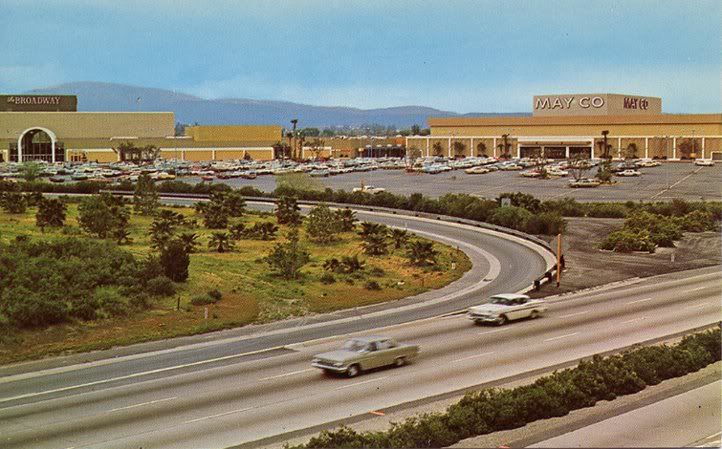
A photograph of the Inland Center Mall circa 1969. Photograph used under a Creative Commons license.

If people in Southern California never quite were familiar with San Bernardino, well, they, along with much of the country, are now very much aware of this city called San Bernardino.

 photo 1950s-pc-sb-dt-3rd-001ac-600.jpg
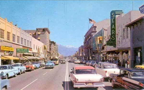
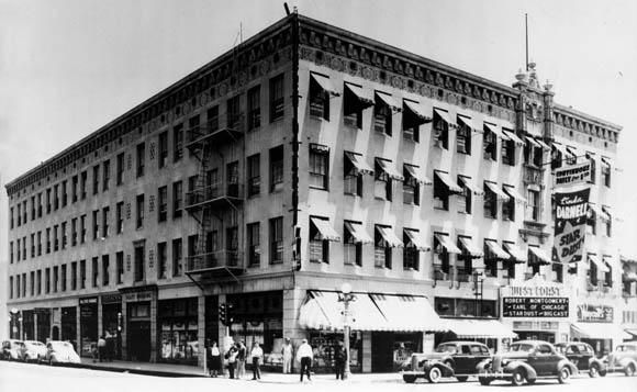
Before Sears moved to the Inland Center Mall it was located in downtown San Bernardino as seen in this circa 1955 photograph. Photograph in public domain.

The Federal Bureau of Investigation uses certain criteria to formally declare a crime to be a "terrorist attack." It appears the recent event in San Bernardino is meeting that criteria set by the FBI. Subsequently, what occurred in San Bernardino on December 2, 2015, may end up being the deadliest terrorist attack within the United States since the terror attacks of September 11, 2001.

Given where the investigation of this mass shooting in San Bernardino, which killed 14 people and injured 21, has led, and where it is continuing to lead, this tragedy has not just national implications, but international implications.

Plenty of things have been written, from the San Bernardino Sun to The New York Times, about what occurred and what is continuing to transpire. We are not going to talk about that here. Since the world's eyes are on San Bernardino here are 15 fun facts about San Bernardino, San Bernardino County and the communities around San Bernardino.


The Mountain Goats singing about "San Bernardino."

1 - The First McDonald's Was In San Bernardino

That's right! The mother of fast food, giver of Happy Meals, with all the excitement and controversy that comes with it, began in San Bernardino.

2 - The Rolling Stones Played Their First U.S. Concert in San Bernardino

 photo 10363588_888135811203333_4984689997011917582_n_1.jpg
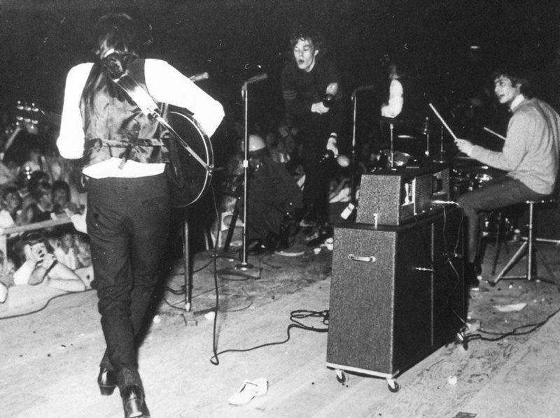
The Rolling Stones at The Swing Auditorium in San Bernardino. Photograph used under a Creative Commons license.

It was San Bernardino radio station K/MEN, back when radio was a really big deal, which brought The Rolling Stones for their very first U.S. performance at The Swing Auditorium in San Bernardino. How this radio station in San Bernardino brought them to the U.S. for the first time is a whole story in and of itself, which we will have in the not too distant future. The short story is, in the wake of The British Invasion K/MEN had a connection in London sending them the latest British hit-makers, and basically looking and hoping to find the next Beatles. Well, K/MEN's London connection sent them an album by "this group that is better than The Beatles," as their London connection described The Rolling Stones. Afternoon K/MEN personality Bill Watson played a cut from the album, suddenly the telephone lines were jammed, and "Mr. Kicks," as Bill Watson was known, did something extraordinarily out of the ordinary for top 40 radio and played the entire album.

 photo RSSwing_1.jpg
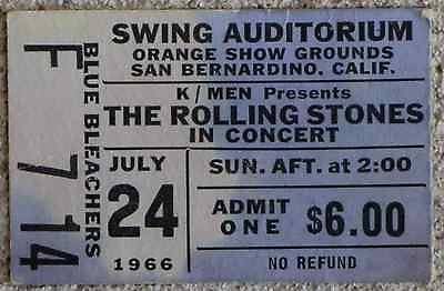
Ticket from a later Rolling Stones performance at The Swing Auditorium. Photograph in public domain.

The Rolling Stones had made plans to tour the United States, but Mr. Watson knew they needed to get this band now! Mr. Watson, calling across The Atlantic, finally got in touch in The Rolling Stones' manager Andrew Loog Oldham. After some deals were cut, and told of the reaction of The Rolling Stones, Mick Jagger and company soon took to the U.S. stage for the very first time in San Bernardino thanks to K/MEN.

3 - Lyndon B. Johnson Had A Job As An Elevator Operator In San Bernardino

 photo PlattBldg_web_1.jpg
The Platt Building in San Bernardino where a future president once worked. Date of photograph unknown. Photograph in public domain.

Future Vice-President and President Lyndon B. Johnson once worked as an elevator operator at a San Bernardino building in 1925. During a 1964 reelection campaign stop in San Bernardino LBJ returned to that building, known as the Platt Building, to operate the elevator once more in front of a few cameras. The Platt Building fell in 1993 after meeting a demolition team under the names of "progress," "redevelopment" and "improvement." Many longtime residents were too happy with this new "improvement," which is to say it was a very conversational move demolishing the Platt Building. Before the Platt Building was torn down the elevator where LBJ worked was saved. 

4 - Home Of The Oldest Operating Jewish Cemetery 

The Home of Eternity Cemetery is the oldest operating Jewish cemetery in Southern California. The land was given to the Jewish community from Mormons in the 1850. 

5 - The Sun Almost Became Apart of the L.A. Times

The San Bernardino Sun has been for many decades, and continues to be, the dominate newspaper in the San Bernardino area (though in the last decade and a half it has faced stiff competition from The Press-Enterprise). Back in the 1960s the Los Angeles Times' then parent company Times-Mirror made an attempt to buy The Sun, but federal government antitrust officials were not too keen on the idea and thus no sale. Today The Sun is apart of the Los Angeles Newspaper Group, which includes, the L.A. Daily News, and Daily Bulletin, Pasadena Star-News, among other Southern California newspapers.

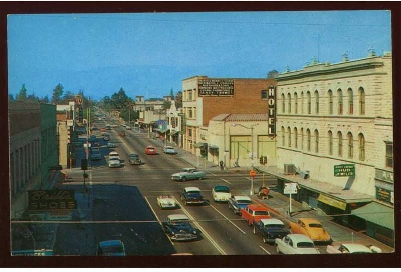
6 -  The Largest City Between L.A. and New Mexico Was Once, Colton

 photo Colton55.jpg
Certainly not Colton during the Californio era, but rather a photograph of downtown Colton from 1955. Public domain.

Near where current day Colton is there was once a town called Aqua Mansa, which was, for a time, the largest town between Los Angeles and New Mexico. It is a very significant place with its roots going back to Californio days. Its residents included the Wilson family and family member Don Benito Wilson. That Mr. Wilson is better known as Benjamin David Wilson who would go on to be the second elected Mayor of L.A., and whom Mount Wilson is named after. 

7 - What Does L.A.'s MacArthur Park Have To Do With Colton?

The writer of perhaps one of the most perplexing pop songs, "MacArthur Park," made famous twice, first by Richard Harris and later as a disco hit by Donna Summer, lived in the Colton area for a time once upon a time, and his name is Jimmy Webb. Mr. Webb also wrote "Up, Up and Away" as performed by The Fifth Dimension, along with many other songs. Mr. Webb even wrote a song about Colton, "820 Latham Street," perform by The Fifth Dimension (who had many rehearsal sessions in Colton) and The Brooklyn Bridge, which is apparently the Colton address where the girl of his dreams (and muse of many songs) lived. Turns out the girl of Mr. Webb's dream from Colton soon moved to L.A. and worked near MacArthur Park, which is where Mr. Webb and the girl from "820 Latham Street" in Colton spent many afternoons together. MacArthur Park ended up being a very special place for Mr. Webb and his girlfriend from Colton, and so he wrote a (long) song about it.


The Fifth Dimension singing about that girl who lives at "820 Latham Street" in Colton.

8 - Colton's First Marshall 

Virgil Earp, brother of Wyatt Earp, was Colton's first Marshall. The Earp house still stands at 528 West “H” Street in Colton. Please do not disturb the current residents.

 photo NS-RTM-PE-1217-Colton-SP-undated-1024x683.jpg
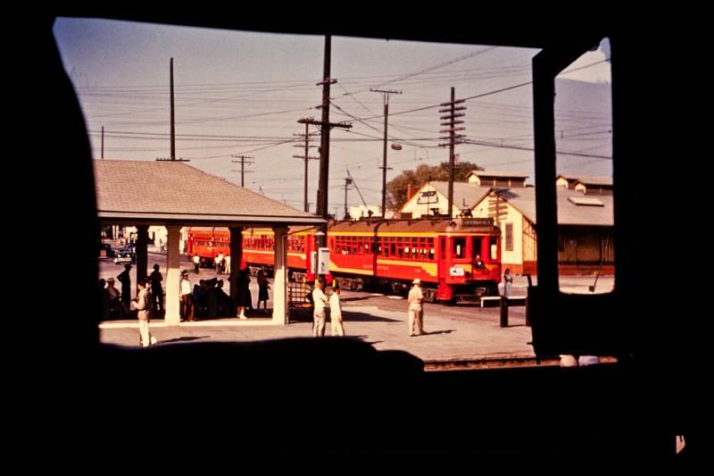
This is a photograph of a Pacific Electric train station in Colton taken long after Virgil Earp was Marshall of Colton. Used under a Creative Commons license.

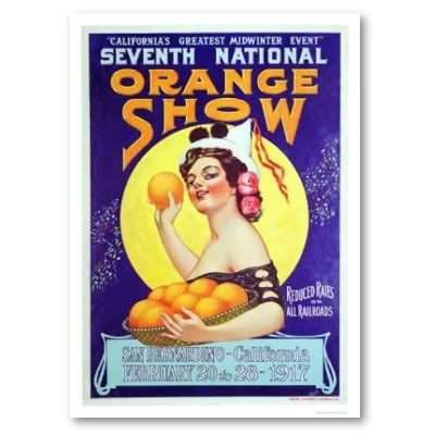
9 - Home Of The Cursed Fair

 photo NOS1917.jpg
Poster for the 1917 National Orange Show. Author's collection.

Most people who grew up or lived in San Bernardino or the Inland Empire for a time will tell you about the "Curse of the Orange Show." Southern California was a citrus empire, and the annual National Orange Show in San Bernardino was a prominent event showcasing the best of the citrus industry. In its glory days "The Orange Show," as so many locals lovingly call it, featured not just A-list stars, but the very top of A-list stars. It was a very glamorous affair, but it always seem to rain on their parade, and many residents say there is a reason for that. Legend has it The National Orange Show Grounds are built atop of a Native American burial ground. The legend goes since it was built atop of Native American burial grounds a curse was placed on the event that makes it rains every time The National Orange Show is held. Records show that in fact, yes, many times during The National Orange Show it has rained. Coincidence?

 photo 20150507-194808-574441.jpg.png
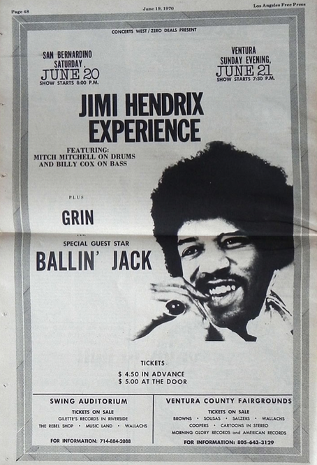
A 1969 ad in the Los Angeles Free Press for The Jimi Hendrix Experience at The Swing Auditorium. Public domain.

(By the way, The Swing Auditorium, where The Rolling Stones played their first U.S. concert as mentioned above, and, also where many bands came through in the 1960s and 1970s, was located on The National Orange Show Grounds. The Swing Auditorium was destroyed by an airplane crash on September 11, 1981.)

10 - San Bernardino Is Bigger Than Switzerland

If you are a regular driver between Southern California and Las Vegas you probably think San Bernardino County is a very large county. You would be right, because that county in the Inland Empire is the largest county within the lower 48 states. San Bernardino County is larger than many states and even many countries. It is bigger than Switzerland. Its record was beat with the admission of Alaska as a state, which has a much larger county.

11 - The Last Two Big California Earthquakes Were In San Bernardino County

The last two magnitude 7-plus earthquakes within California were in San Bernardino County. Those quakes were, the 1992 Landers Earthquake and the 1999 Hector Mine Earthquake.

12 - Home Of The Tallest Mountain Peak In Southern California

Many people really do not like earthquakes, and that is very understandable, but earthquake faults give us in Southern California spectacular hills and mountains. One of those mountains is Mount San Gorgonio. Located in San Bernardino County in the San Bernardino Mountains reaching a peak of 11,503 feet Mount San Gorgonio is the tallest mountain in Southern California. On a very clear day you can see Mount San Gorgonio from downtown Los Angeles and by the beach in Santa Monica.

13 - The 100th In The Nation

In covering the tragic event many reporters from around the country and around the world noted that San Bernardino is not quite a small city, and for good reason. According to the 2010 U.S. Census the 100th largest city in the U.S. is San Bernardino. As well, San Bernardino is the 17th largest city in California.

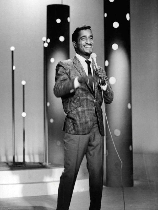
14 - Where Sammy Davis Jr. Lost His Eye

 photo Sammy_Davis_Jr._performing_1966.jpg
Sammy Davis Jr. performing on NBC in 1966. Photograph in public domain.

In 1954 on the way home to L.A. from performing in Las Vegas Sammy Davis Jr. was in a car accident on Route 66 at Cajon Boulevard and Kendall Drive. That is where Sammy Davis Jr. lost his eye. It would be at San Bernardino Community Hospital where Sammy Davis Jr. would recover. While at the hospital his friend, Eddie Cantor, met with him and talked about the similarities between Jewish and black culture. It was at that moment, so the story goes, Sammy would begin his conversion to Judaism. Sammy was so grateful for the services he received at San Bernardino Community Hospital he held an all-star fundraiser at The Swing Auditorium for the hospital.

15 - Home Of The Hell's Angels

Started by the Bishop family in Fontana the motorcycle club that would set the standard for "outlaw motorcycle clubs" and go on to much notoriety began in San Bernardino County.


Certainly not a tune by The Hell's Angels, but rather, a tune from Frank Zappa, who had a studio in Ontario.


Monday, June 29, 2015

Seven Facts About The Landers Earthquake

THE HOT MOJAVE DESERT IN SAN BERNARDINO COUNTY - Little earthquakes, many of them very little earthquakes, shake Southern California everyday. However, it was on June 28, 1992, on which the largest county in the lower 48 states was the epicenter of the largest earthquake in California in about 40 years. Though not a lot of spectacular, memorable damage was done, there were a lot of lessons learned from this earthquake.

 photo 640px-Landers_quake_bowling_alley.jpg
Probably the most noticeable damage following the 1992 earthquake was this bowling alley in Yucca Valley. Photograph taken by the National Oceanic and Atmospheric Administration and in public domain.

Waking Southern California up on a Sunday morning at 4:57 a.m. in the very busy year of 1992 here are seven interesting facts about the earthquake commonly known as, "The Landers Earthquake."

1 - It Still Remains The Last Largest Earthquake In California

It has been over 20 years and the Landers Earthquake was, according to the moment magnitude scale (M), a M7.3 earthquake, and (as of this writing) retains the record as being the last large earthquake, by way of magnitude, to hit California. Prior to the 1992 event the last large earthquake to hit California was the 1952 Kern County Earthquake, which occurred near Wheeler Ridge on the (thought to have been inactive) White Wolf Fault, and was M7.3. After the Landers Earthquake the next closest earthquake in magnitude size was the 1999 Hector Mine Earthquake at M7.1.

Even though this earthquake was rather big, it was not "The Big One." In fact, "The Big One" is expected to be M7.8-8.0.

As paleoseismology has shown this record held by the Landers Earthquake will likely be broken at some point.

2 - There Was A Lot Of Fault Involved

Rather, lot of faults were involved. The Landers Earthquake did not just rupture on one single fault-line, but rather ruptured on five separate fault-lines: Johnson Valley, Landers, Homestead Valley, Emerson, and Camp Rock Faults, according to the Southern California Earthquake Data Center (SCEDC).

3 - A New San Andreas Fault Could Be Opening Up

That is the theory, at least, from Lawrence Berkeley National Laboratory (LBL) geologist Pat Williams. According to the LBL article that came out in August 1992:

A theory that was posed in the aftermath of last month's earthquakes was that a new San Andreas fault could be opening up from the Salton Sea north to central California. Williams says instead that the recent activity has linked the Gulf of California with slip systems east of Mount Whitney, the 1872 site of one of California's three historic magnitude 8.0 earthquakes.

Williams' theory is that the strain is heading toward the back side of the Sierras, northeast into central Nevada, where it may affect active geothermal fields. The earth's movement could enhance the production of geothermal fluids by contributing to a thinning of the crust and allowing the fluids to circulate through complex fractures.

A huge strain response on a scale never seen before occurred during the 24 hours following the Landers earthquake. At the Pinion Flats Observatory researchers from UC San Diego observed a massive redistribution of strain deep in the earth's crust. For the first time, Williams says, scientists will be able to study not just how the upper 12 kilometers of brittle crust reacts, but the response of the deep crust beneath it.

This theory is still being debated among geological and seismologists circles, and, frankly, it will probably take a few more large earthquakes to see if this theory is correct. The earth sciences is sometimes a game of wait and see.

4 - Did You Feel The Foreshock?

At the time nobody knew it was a foreshock to the Landers Earthquake, and in fact, there was concern this might have been a foreshock to a San Andreas Fault event, and that was a M6.1 foreshock that hit about 11 miles east of Desert Hot Springs on April 23, 1992. The Earth Day earthquake caused a moderate amount of property damage in the Palm Springs area. As this earthquake, called the Joshua Tree Earthquake, rolled through to Los Angeles at 9:50 p.m. a Dodgers' game was going on and Vin Scully broadcast the the rolling motion happenings at Chavez Ravine.

There was concern this could be a foreshock to a San Andreas' event, and, according to the SCEDC, "A San Andreas Hazard Level B was declared following this quake, meaning that a 5 to 25% chance existed for an even larger earthquake happening along the San Andreas fault within 3 days."

This made for some big headlines in L.A. media, but by April 29, 1992, this earthquake and the threat of the San Andreas Fault unleashing its fury would be forgotten, at least for a little while.

This foreshock had its own foreshock, a M4.6, a little over two hours earlier.

5 - Was The Big Bear Earthquake Really An Aftershock?


This was the Big Bear Earthquake broadcast live on CNN to the country and parts of the world.

The short answer, no.


This is a report of the earthquakes from KTVU-TV, Oakland/San Francisco, which includes on-air coverage from KTTV-TV as the Big Bear Earthquake shook the KTTV/Fox 11 newsroom at the now gone Metromedia Square in Hollywood.

At 8:05 a.m. on that Sunday morning a lot of people were already up and had already felt quite a few aftershocks, but one the largest, and probably most damaging, earthquake that morning was the Big Bear Earthquake. It was originally thought the M6.5 Big Bear Earthquake was simply an aftershock, and having an aftershock of that size following such a large earthquake is not unusual. However, as later research showed, the Big Bear event was not an aftershock of the Landers Earthquake. Rather, that earthquake in the San Bernardino Mountains was apart of a "regional earthquake sequence," according to the United States Geological Survey (USGS).

6 - Location And Magnitude

 photo 510px-USGS_ShakeMap_-_1992_Landers_earthquake.jpg
While there was some strong shaking in the Inland Empire, L.A. area, Orange County and San Diego area, all of the violent shaking, which causes severe damage, was in mostly unpopulated areas of the San Bernardino County desert. "Shakemap" by USGS and in public domain.

Even though the Landers Earthquake was a historically large, powerful earthquake, the epicenter was seemingly in "the middle of nowhere," and damage was mostly minor-to-moderate (if you were somebody who lived near the epicenter in "the middle of nowhere" it was, no doubt, not quite a good morning). The Big Bear Earthquake a little over three hours later, and a lot less powerful than the Landers' event, was in a more populated area, and thus more damage was caused despite it only being a moderate-size earthquake. The Northridge Earthquake vividly showed that it only takes a moderate-sized earthquake in an urban area to cause major damage. So, even though an earthquake may be quite large (and scary sounding to those around the country who only hear, "A 7.3 earthquake struck the L.A. area on Sunday morning"), if it is located in a very sparsely populated area very little property damage will be found. This, too, would be visibly illustrated following the 1999 Hector Mine Earthquake.

7 - The Landers Earthquake Happened One Year After The Sierra Madre Earthquake

Some people have forgotten about this earthquake, but on June 28, 1991, a M5.8 earthquake struck in the Angeles National Forest about 12 miles northeast of Pasadena in an event called, The Sierra Madre Earthquake. It is interesting and curious that some people have forgotten this event as this earthquake caused some major property damage in the Pasadena area, such as, windows shattering and brick-walls collapsing. One of this interesting things about this earthquake was for a quake of its size it had a small aftershock sequence.

No, despite these earthquakes occurring a year apart they are not related.


Saturday, May 30, 2015

Seven Random City Fun Facts: Colton

COLTON - Motoring rapidly along Interstate 10 perhaps on the way to Palm Springs for some sunshine and retro decor, or maybe you are driving all the way to the I-10's eastern terminus in Jacksonville, Florida, one of the many cities you come across is Colton. A fast glance at Colton shows no more than a typical Southern California suburb that is part of the puzzle piece making up the megalopolis that is the Los Angeles Basin.

 photo Colton55.jpg
The intersection of what is now Valley Boulevard and La Cadena Drive before the "development bomb" of the 1960s. Used under a Creative Commons license.

As is the case with many places across Southern California there is more to Colton than meets the eye. In fact, would you believe that Colton is connected to Mount Wilson, "MacArthur Park" and the Chicano movement. Sadly, as it also the case with many cities across Southern California, much of that has been erased in the name of progress.

The city, once called The Hub City, which is wedged between the cities of San Bernardino and Riverside, has an interesting background, and here are seven random fun facts about Colton.

1 - The writer of perhaps one of the most perplexing pop songs, "MacArthur Park," made famous twice, first by Richard Harris and later as a disco hit by Donna Summer, lived in the Colton area for a time once upon a time, and his name is Jimmy Webb. Mr. Webb also wrote "Up, Up and Away" as performed by The Fifth Dimension, along with many other songs. Mr. Webb even wrote a song about Colton, "820 Latham Street," perform by The Fifth Dimension and The Brooklyn Bridge, which is apparently the Colton address where the girl of his dreams (and muse of many songs) lived. Turns out the girl of Mr. Webb's dream from Colton soon moved to L.A. and worked near MacArthur Park, which is where Mr. Webb and the girl from "820 Latham Street" in Colton spent many afternoons together.


"820 Latham Street" as performed by The Fifth Dimension and written by Jimmy Webb.

2 - Once upon a time the community of Agua Mansa, now in modern day Colton and the name of a historic cemetery, was the largest town between Santa Fe and Los Angeles, and was a very important place in the Californio era. One Benjamin Davis Wilson, or Don Benito Wilson as he was known to the Native Americans, and who would go on to become mayor of L.A. and whom Mount Wilson is named after, had his life saved here by Lorenzo Trujillo after Mr. Wilson was involved violent battle with a Native American named Joaquin.

3 - Jimmy Webb was not the only musically famous person to come out of Colton. Jim Messina of Loggins and Messina and The Buffalo Springfield is also from Colton.

4 - Virgil Earp, brother of Wyatt Earp, was Colton's first Marshall. The Earp house still stands at 528 West “H” Street in Colton. Please do not disturb the current residents.

5 - Colton was created by promoters of the Southern Pacific Railroad (known in fiction as, The Octopus, by author Frank Norris), and the name Colton comes from, David Douty Colton, who was the vice president of Southern Pacific Railroad. Southern Pacific intended to make Colton the railroad center of Southern California. Mr. Colton probably made a couple trips to the city named after him, but he lived in San Francisco.

6 - The Chicano movement was, and still is, very strong in Colton. In fact, in clashes with police in 1943 there was even, sadly, a "Colton Zoot Suit Riot." This soon lead to a larger Chicano movement in Colton with protests against the police and demands for better services from the city. The protests were heard, and in the early 1950s a Chicano councilman was elected. By 1979 Colton elected a Chicano mayor and two Chicanos on the City Council, as well as a Chicano school board member. Colton was one of the first cities in Southern California to have such a strong representation of Chicanos in government.

7 - If you have driven through Colton in recent years, or really, for the past 20 years, you may notice it looks nothing like the photograph above. So what happened to Colton's downtown as shown in the photograph above? Well, the short answer is Colton made the decision (or mistake) many cities around the country made, and that was redevelopment. It is way too easy to say today that they should never have bulldozed their downtown, but remember when malls came in vogue that resulted in shoppers and businesses leaving city centers and downtown areas en mass for these new shiny, modern malls. The shoppers and businesses took their dollars with them to these new malls, and many cities, like Colton and even nearby San Bernardino, took the redevelopment route and basically wiped out their old downtown for what was suppose to be a new, modern shopping area that was going to bring business back. In Colton, and San Bernardino, it never quite worked and many long time residents regret the decisions their city leaders made. Some locals and former locals call it, "the development bomb."


Saturday, April 18, 2015

The Highway Fire Photographs

CORONA - Little rain, a major, historic drought, very dry vegetation, a gentle wind and a spark has brought about a major brush fire where Orange County, Riverside County and San Bernardino County meet in what is the explosive start of a dreadful fire season.

Monday Update: According to the Riverside County Fire Department, the fire is holding at 1020 acres with 35% containment, and all evacuations have been lifted. No homes or structures were damaged or destroyed.


A massive brush fire has broken out in the Corona/Chino/Norco area with flames rapidly moving in a northeast direction being driven by light-to-sometimes-gusty winds, which has prompted evacuations in what is being called The Highway Fire. The fire is burning in the Prado Flood Control Basin, which has thick, tender dry brush that has not burned in many decades.

By day smoke could be seen throughout much of Southern California and by nightfall an ominous orange glow could be seen for many miles around.

At least 300 homes have been threatened by this fire. As of this update no homes have been lost. There was a rumor going around that two homes had been destroyed, but Cal-Fire says NO homes have been lost.

The American Red Cross has established an evacuation center for residents at Riley’s Gym, 3900 Acacia, in Norco, while those who have animals can evacuate them to Ingalls Park on Sixth Street in Norco. UPDATE: The evacuation center has been closed, because apparently nobody needed it and had another place to go.

By midnight the breezy and sometimes gusty winds had tampered off giving the 800 firefighters on the scene the much needed upper hand in fighting this conflagration, which at 12:20 a.m. is at 30-percent containment. Rising humidity levels and cooler temperatures are also helping.

The Riverside Freeway and Chino Hills Freeway are open.

 photo CoroFire.jpg
The scope of this massive fire. This photograph was taken around 10 p.m. on Saturday on Green River Road in Corona. From this angle the fire was about five miles wide. Photograph by Jason C. Rosenthal.

 photo CoFire6.jpg
The Tombstone and dead, dry palm tree still stands as the fire was being driven by on-shore winds pushing flames in the northeast direction away from this location off Serfas Club Drive in Corona. Photograph by Jason C. Rosenthal.

 photo CoFire4.jpg
See if you can make out the eerie eyes in the smoke. Photograph by Jason C. Rosenthal.

 photo CoFire5.jpg
The Riverside Freeway will do anything to avoid being an effective freeway. Photograph by Jason C. Rosenthal.

 photo CoFire7.jpg
One of many dark smoke plumes. Photograph by Jason C. Rosenthal

 photo CoFire2.jpg
Mr. Tree shaking his arms in fear seeing the danger ahead. Photograph by Jason C. Rosenthal

 photo CoFire3.jpg
Taken about a half-hour after the fire started, and by this time had already put out an enormous amount of smoke that could be seen throughout much of Southern California. Photograph by Jason C. Rosenthal. 

In the past week as dry, warm weather gripped Southern California a handful of small brush fires broke out. Earlier Saturday a brush fire burnt about 12-acres in Fullerton. Earlier in the week a brush fire destroyed one home in Jurupa Valley.

As well, earlier in the week two small brush fires broke out in Malibu, but were quickly put out. Also, firefighters quickly fought a small brush fire in Whittier.

Even though it seems like every year we are told, "it is going to be a bad fire season," in an April 11 interview with the Los Angeles Times a Jet Propulsion Laboratory climatologist says this year is a particularly "incendiary situation," and we should treat every day from here on through next winter as fire season.

It seems The Highway Fire has driven home the point just how serious this fire season will be, because this fire took a lot of people by surprise on just how fast it moved and grew.

[Feel free to share these photographs. Sure, these are not the best, but still, just give credit.]


Monday, March 3, 2014

Know Your Faults: The Whittier Fault

(This is an occasional series exploring the many earthquake fault lines in and around Southern California. This series is not intended to be a scholarly, scientific review of earthquake faults throughout Southern California, but hopefully will be a jumping off point for you to understand and further explore the fault lines that cross Southern California. )

BREA - Standing in the parking lot of the Brea Mall turning your head from the southeast to the north and slowly to the northwest you see vivid brown hills dotted with trees and homes lining the landscape. These hills provide a natural border between Orange County and the Inland Empire, and Orange and Los Angeles Counties. Like many of the hills and mountains that provide a majestic backdrop for Southern California there is a hidden danger in the hills, which resulted in the creation of these hills.

As geologists and seismologists have pointed out, anytime you see a hill or mountain in California chances are very good you are looking at an earthquake fault. If you are in Orange County looking at the hills above Brea, Yorba Linda and La Habra, or in the San Gabriel Valley checking out the hills that sort of parallel State Route 60, you are looking at the work of the Whittier Fault.

How Often Do Big Quakes Happen?

Like many earthquake faults in Southern California there are some things known about the Whittier Fault, but a lot that is not known about the fault. One of the most important things not known about this fault is the interval between major ruptures. What is known are United States Geological Survey studies showing the Whittier Fault is capable of producing an earthquake between 6 to 7.2 on the moment magnitude scale

What all that means is this, the USGS currently has no data on how often the Whittier Fault produces a major earthquake, and that is rather unfortunate, because that would give seismologists a rough forecast of when the next major quake may strike. 

About the only thing USGS knows about the last major earthquake on the Whittier Fault is that it occurred sometime in the last 10,000 years, otherwise known as the current Holocene era. As well, the slip rate is about 2.5 and 3.0 millimeters per year, according to USGS.

Where Is The Whittier Fault?

The fault line is a branch of the quiet giant Elsinore Fault, and going east-to west the fault begins just north of SR 91, up and above Gypsum Canyon Road at Bryant Ranch Park near Bryant Ranch Elementary School in Yorba Linda. Going in a west-northwest direction the Whittier Fault runs on the southwest section of Chino Hills State Park, crossing through Carbon Canyon Regional Park and crossing Carbon Canyon Road/Lambert Road. The fault continues to run in a northwest direction in the hills above Lambert Road and crossing very close to Brea Olinda High School, then crossing SR 57, crossing into the Humble Reservoir, crossing Brea Boulevard, and going in a more northwest direction into the hills above La Habra, crossing Harbor Blvd just south of Vantage Pointe Drive.

From that point the fault continues to run in a gentle northwest direction crossing "E" Road north of the Hacienda Golf Club into La Habra Heights, crossing Hacienda Road at about Skyline Drive going into Arroyo Pescadero Trail and then crossing Colima Road just south of Casino Drive. The Whittier Fault makes a more sudden northwest turn into Turnbull Canyon, crossing Turnbull Canyon Road/Beverly Blvd. and ending at Hellman Wilderness Park in the hills above Whittier.

Just How Bad Could A Big Quake Be?

A major rupture on the Whittier Fault could end up being a historic American disaster.

A scenario by USGS predicts that if a M6.8 occurred at 5 p.m. on the Whittier Fault there would be 9.450 injuries and fatalities, and predictions of building damage to be nearly $20 billion.

 photo intensity.jpg
USGS Whittier Fault earthquake scenario map. Shown for educational and informational purposes only; no copyright infringement intended.

It is important to understand that anytime you get at or above a magnitude 6 that occurs in an urbanized area you begin to see structural damage, even in a place like Southern California, which is suppose to be "built" to withstand a major earthquake.

Also, remember that the Whittier Fault runs near several of Southern California's older neighborhoods and old downtown areas, such as Fullerton, Orange and Whittier, and a major event on the Whittier Fault could severely impact those places and older neighborhoods in the San Gabriel Valley. Depending on the dynamics of a major earthquake on the Whittier Fault it is certainly possible the old downtown areas of Pomona, Claremont and Ontario could see structural damage.

Again, depending of the dynamics of a major rupture on the Whittier Fault, it is very possible that even L.A. proper could see structural damage. 

What it comes down to is the Whittier Fault has the potential to cause major damage in the four county L.A. metro area.

Possible Major Freeway Damage

Let us not forget if there is a major rupture on the Whittier Fault that breaks on the surface the 57 freeway could see major damage. You add major damage on the Orange Freeway, along with possible major damage on the streets that connect L.A. and Orange Counties through the hills, and perhaps possible damage on the Riverside Freeway, you have the makings of a major commuter nightmare that could result in more economic losses. 

The 60 freeway, which seems to be the choice of truckers shipping goods from the Port of L.A. and Long Beach to the Inland Empire and points east, could also be structurally impacted by a major Whittier Fault event. It is not far fetch to say damage on the Pomona Freeway could reverberate throughout the nation.

Not At Fault

If you grew up in Southern California you probably remember the 1987 Whittier Narrows Earthquake, but it is worthy to note that earthquake was not on the Whittier Fault, but rather ruptured a small and previously unidentified, gently north-dipping,west-striking thrust fault, according to USGS. Seismologists originally thought this earthquake was caused by the Elysian Park Fault

Furthermore the somewhat recent 2008 Chino Hills Earthquake, which was the last magnitude 5-plus to occur in the L.A. basin, is not believed to be the work of the Whittier Fault nor Chino Fault.

What Can You Do?

All you can do is prepare. Prepare for the next major earthquake on whatever known or unknown fault it occurs on in Southern California.

No One Knows When!

At this time, and unfortunately probably for many years to come, there is no accurate way to predict when any earthquake is going to strike. The only earthquakes that can be predicted are aftershocks, and sometimes those can take geologists and seismologists by surprise.

Despite what any person or any group claims about predicting earthquakes at this time, quite frankly, there have been no proven concrete methods to accurately predict earthquakes.

The bottom line, you just need to prepare.


Monday, February 10, 2014

Go Do This: Get A Flu Shot

AT A CLINIC SOMEWHERE ON VALLEY BLVD - If you have not already felt the pinch in your arm then it is time for you to go get a flu shot. It is a very nasty flu season bringing a lot of people down, including the guy on the other end of the computer typing up this piece.

Not sure where to go get the shot? Well, here is a handy bit of information from the Los Angeles County Public Department. Or not in L.A. County and a little further east along Valley Boulevard, well check out the County of San Bernardino Department of Public Health flu site. Of course if you find yourself south of the L.A. County line in the Orange Curtain please check out the Orange County Public Health Department flu page. Of course if the flu tries to chase you down eastbound along Pomona Freeway or Riverside Freeway do visit the Riverside County Department of Public Health for information how to get a flu shot for you.

 photo wwwwallpapernamecom_46.jpg
Author unknown. Shown for educational purposes only; no copyright infringement intended. 

Shots are very dreadful to be sure, but the flu is much worse. Just make an appointment and get it over with. Your body will thank you, your stomach will thank you, and everybody around you will thank you.

Life is much too short to be ill for too long, so break out the needle, drop it on your arm and have a ball, please.