Thursday, February 27, 2014

Oh...My...GOD!!! It's RAIN!

WEATHER STATION ATOP SANTIAGO PEAK - In case you have not heard rain is falling, or will be falling shortly, across Southern California. Of course if you watch local broadcast media you have heard all about this, because on local television this is being treated like a Category 5 hurricane is about ready to make landfall in the Santa Monica Bay.

Despite the typical, and just down right baffling, over-hype of rain falling in Southern California, there are some legitimate stories concerning these storms.

If you have not heard, California is on the verge of a historic drought, which is so bad Governor Jerry Brown declared a drought emergency earlier this year and President Barack Obama pledged aid to help California's drought. Now these series of storms will not end it, but every little bit helps. A major drought in California has not just severe ramifications in The Golden State, but throughout the nation and even the World as we are major supplier of food.

The Los Angeles Basin has been very dry, and these storms are expected to make up for that short fall.

These winter storms are also a financial boost to the local ski resorts and mountain towns, which have not seen very much snow.

Also, please remember, even though we are getting some water from the sky, to shut off your sprinkler system.

Furthermore, relax, despite all the media hype it is just rain. It typically happens this time of year.

A Quick Did You Know: Anaheim Blvd Was Once...

ANAHEIM - Did you know, Anaheim Boulevard, which of course runs right through Anaheim, was once called Los Angeles Street.

Did you also know, Interstate 5 that runs through Anaheim was once proposed to be called the Manchester Freeway.

Wednesday, February 26, 2014

A Simple Plea: Bring The Winter Olympics to Southern California

 photo 800px-Olympic_Ringssvg.png
Shown for educational and information purposes only; no copyright infringement intended. 

HEAPS PEAK IN THE SAN BERNARDINO MOUNTAINS - The Sochi Olympics have wrapped up, bringing to end the somewhat contentious XXII Olympic Winter Games. Among the many real or perceived problems, there was one real problem, which is the Sochi games were just a little too warm for the Winter Olympics. The climate in the Sochi area is typically rather mild and Russian officials stored significant amounts of snow for the games, just in case. Nonetheless, despite social issues outside the gates and the unrest in nearby Ukraine, the Sochi games went off without any real problem, and the events themselves were an overall success.

So, if a place like Sochi can pull off a Winter Olympics then why cannot our own Southern California mountains, The San Gabriel and San Bernardino Mountains, host the winter games? After all, the weather in our local mountains are about the same as in Sochi, you never quite know if it is going to be a snowy year or warm year, and if it is warm our ski resorts know how to make and store quite of bit of snow. 

Where In Our Mountains?

Probably the most logical site for the home-base of the Winter Olympics would be Big Bear, but however events could be spread all over the Transverse Range. Spreading out Olympic events is nothing new. It was done in Sochi, and it was done during the 1984 Summer Olympics in Los Angeles with many Olympic games spread throughout Southern California.

Sure, there would be some infrastructure that would need to be built, but that would be a boom to the local construction industry. 

Okay. All This New Stuff Is Built, But What Happens When The Games Leave?

Some may ask what happens when the Olympics leave the mountain resorts with so much new stuff built? Well, for places in Big Bear, and perhaps other places in the San Bernardino and San Gabriel Mountains, they can now brag and sell their ski resorts as being world famous, and boost their ski resorts from being local destinations to world destinations. What skier would not love to play and ski at an Olympic ski resort?

What About The Mountain Roads?

What about accommodating all the Olympic spectators, and those mountain highways?

Yes, as any person who has driven our mountain highways and roads can attest, the roadways to and around the mountain towns are not the best, and can provide for a white-knuckle ride at times, but this would provide the opportunity to improve the mountain highways.

Furthermore, shuttle service can be provided to and from events, and up and down the mountain. Also, this may be an opportunity to explore other unique forms of transportation, such as a tramway from the base of the mountain to perhaps Big Bear, not unlike the Palm Springs Tram

Just Where Is Everybody Going To Stay?

In the mountain towns there would be a need to build some new hotels, but there are many hotel and motel rooms down the mountain in the Inland Empire that are underused and could be used to house Winter Olympic spectators.

Of course before, during and right after the Olympic games it will be massive boost to the hospitality industry, and not just in the mountains, but it will have a positive ripple affect throughout Southern California. It is not an unlikely scenario that hotels from Palm Springs to L.A. would be filled up with Winter Olympic spectators. 

What About Traffic Down Here?

What about traffic having a ripple affect in the flat lands? Well, we all worked together during the 1984 games, and the recent events on Interstate 405, and so why cannot it be that way again for the Winter Olympics?

Consider It and Bring It To Our Mountains!

We say to the powers that be, bring the Winter Olympics to the Southern California Mountains. We have, and could easily have, the infrastructure in place, and hosting the games here you would not have to worry about any possible social problems taking center stage at the games. The United States is a very stable place to hold the Winter Olympics, and our Southern California mountain range will make it even better.

As an added bonus to consider, though it is on a smaller scale, Big Bear has hosted the X-Games, among other such winter events.

The Winter Olympics in Southern California? Yes, this can be done.

We have already hosted two Summer Olympics, and let us make our third hosting of the games The Winter Olympics!

This can be done, and so let us do it!

Thursday, February 20, 2014

Have You Ever Wondered: Why Is The Freeway Name This Way?

LA PUENTE - If you are one of many regular commuters who drive between Los Angeles and Orange County and the Inland Empire, have you ever wondered why State Routes 60 and 91 have the names that they do?

Why is the 60 freeway named The Pomona Freeway when it goes well past Pomona and directly into downtown Riverside?

Why is the 91 freeway called The Riverside Freeway when it does not go into downtown Los Angeles, but through Orange County? 

The 91 somewhere along the L.A. and Orange County line kind of becomes The Artesia Freeway. Seems to have made more sense to name it The Torrance Freeway.

Wednesday, February 19, 2014

Knowing Your Faults: The Elsinore Fault

(This is the first in an occasional series exploring the many earthquake fault lines in and around Southern California.)

ALONG THE EASTERN EDGE OF THE CLEVELAND NATIONAL FOREST - Today, like everyday before and after, the Earth keeps spinning and tectonic plates keep slowly sliding by each other. In our part of the world it is the Pacific Plate slowly sliding north along the North American Plate, and sometimes the sliding and grinding of those two plates make its presence known in Southern California in the worst way possible.

(As the Pacific Plate slowly inches its way north in many millions of years from now Southern California will become apart of the Bay Area, and finally have a NFL football team).

It has now been over 20 years since the Los Angeles Basin experienced a severely damaging earthquake, and nearly 15 years since a magnitude 7 earthquake occurred within Southern California. Aside from the passing minor jolt here and there the ground under Southern California has been quiet, and that worries some seismologists at the United States Geological Survey. Now they are not worried that all this quietness means a big quake, or "the big one," is coming. Rather, since it has been so quiet and Southern California has not had any real notable earthquake in many years USGS officials are worried that some people may not be taking earthquake preparedness seriously.

We know Southern California brings in transplants from all over the country and the world, and hopefully they learn a little bit of history on their new home and realize historically Southern California is disaster prone.

In this Knowing Your Faults series since it has been so seismically quiet we figured the best way to start this series is to explore one of the "quietest" faults in Southern California, The Elsinore Fault.

The Elsinore Fault is a major fault system, and in fact it is one of the largest faults in Southern California capable of producing a major earthquake, but for such a large fault it has been very seismically inactive. 

Why So Quiet? 

Well, geologists and seismologists are not entirely sure. There are a lot of working theories why the Elsinore Fault may be so quiet. One of the floating theories is the San Jacinto Fault and Newport-Inglewood Fault may possibly be taking stress off The Elsinore Fault. It is one of many mysteries of earthquakes that have yet to be solved.

Where Can You Find the Fault?

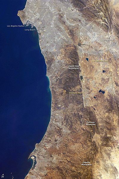
Going from south-to-north The Elsinore Fault starts at the southern section of Anza-Borrego Desert State Park, just a few miles north of Interstate 8, and runs in a northwest direction skirting the northeast side of Cuyamaca Rancho State Park, through Palomar Mountain State Park, through Temecula, crossing I-15 and seemingly paralleling I-15 a couple miles west of the freeway with the fault going through Murrieta, Wildomar, Lake Elsinore, and into southwest Corona. 

It is in Corona where the Elsinore Fault splits into two separate faults, the Chino Fault going northwest and the Whittier Fault going in a west-northwest direction. Both faults cross State Route 91.

It is the Elsinore Fault that helped create the Cleveland National Forest, and what amounts to a natural, mountainous border between Riverside and Orange Counties.

 photo 398px-SoCal_Coast.jpg
NASA Photograph. Shown for educational purposes only; no copyright infringement intended.

Just How Bad Would Such a Quake Be?

Should the day come when the Elsinore Fault decides to wake up with a bang seismologists at the Southern California Earthquake Data Center believe the fault is capable of producing up to a magnitude 7.5 earthquake.

As USGS Doctor Lucy Jones told the San Diego Union-Tribune in 2005, "In Temecula, the 7 on the Elsinore will be much worse than the 8 on the San Andreas."

Should there be a major rupture of the Elsinore Fault at around magnitude 6.8 heavy damage is expected along the I-15 cities through Riverside County, and moderate to major damage is expected in central Orange County, according to studies by the Southern California Earthquake Data Center. The same study shows injuries and fatalities to be at 9,495, and damage to be near the $20 billion mark. 

If a large earthquake occurs there is also the possibility of major damage along the Riverside Freeway through the Santa Ana Canyon, which would bring extraordinary havoc to the entire Southern California freeway system.

Of course freeway problems may be the least of problems as a large earthquake could possibly break Diamond Valley Lake's 284-foot-high dam, and within ten minutes could flood the Riverside County cities of Menifee, Winchester and French Valley, according to Riverside County Emergency Service Director Mary Moreland.

The above is presuming The Elsinore Fault ruptures on its own fault in western Riverside County. There have been scenarios floated by USGS that the north end of The Elsinore Fault could rupture in Corona and the rupture could continuing "moving" along the either Chino Fault or Whittier Fault.  
  
The Elsinore Fault Earthquake History  

So, just how often does the Elsinore Fault move? According to USGS studies the interval between ruptures is about 250 years. 

Just when was the last rupture, well, USGS studies put it somewhere in the 18th Century.

The last notable earthquake on the Elsinore Fault was a magnitude 6 near Temescal Valley in 1910. 

Based on these studies it is believed the Elsinore Fault, like so many earthquake faults in Southern California, is likely overdue for a major earthquake.

When Is It Going To Happen?

With any basic knowledge and understanding of earthquakes your guess, quite frankly, is about as good as those at USGS. 

When it is going to happen nobody knows, and at this time there is no accurate way to predict earthquakes.

All you can do is be prepared, and know the hazards of where you live and work.

Editors Note: While this series is not intended to be a scholarly, scientific review of earthquake faults throughout Southern California, we hope this series will be a jumping off point for you to understand and further explore the fault lines that cross Southern California.

Monday, February 10, 2014

Go Do This: Get A Flu Shot

AT A CLINIC SOMEWHERE ON VALLEY BLVD - If you have not already felt the pinch in your arm then it is time for you to go get a flu shot. It is a very nasty flu season bringing a lot of people down, including the guy on the other end of the computer typing up this piece.

Not sure where to go get the shot? Well, here is a handy bit of information from the Los Angeles County Public Department. Or not in L.A. County and a little further east along Valley Boulevard, well check out the County of San Bernardino Department of Public Health flu site. Of course if you find yourself south of the L.A. County line in the Orange Curtain please check out the Orange County Public Health Department flu page. Of course if the flu tries to chase you down eastbound along Pomona Freeway or Riverside Freeway do visit the Riverside County Department of Public Health for information how to get a flu shot for you.

 photo wwwwallpapernamecom_46.jpg
Author unknown. Shown for educational purposes only; no copyright infringement intended. 

Shots are very dreadful to be sure, but the flu is much worse. Just make an appointment and get it over with. Your body will thank you, your stomach will thank you, and everybody around you will thank you.

Life is much too short to be ill for too long, so break out the needle, drop it on your arm and have a ball, please.

Tuesday, February 4, 2014

Go To This: See Big Boy in Colton

COLTON - There was a time in American history not too long ago when big, massive locomotives pouring out massive thick dark smoke ruled the rails. Some of these locomotives are what built part of Southern California (sometimes in nefarious ways), and perhaps more than a few people remember when they can hear and see the big smoking locomotive rolling down the tracks. 

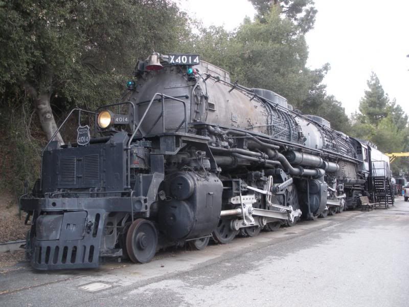
Among these massive trains that once ruled the rails were Union Pacific No. 4014, otherwise known as Big Boy, and before it leaves Southern California you have one last chance to see it.

 photo 
union_pacific_big_boy_4014_in_pomona_by_rlkitterman-d4pf5bp.jpg

Union Pacific No 4014 Big Boy on Display in Pomona. No copyright infringement intended; shown for historical and educational purposes only.

Yes, it is bad news is a historic piece of history is leaving Southern California, but unlike many historic things that have left us forever there is actual good news here.

In January for the first time in nearly 52 years the wheels on Big Boy turned again and the big old locomotive was back on the tracks as Big Boy will be headed to Union Pacific's Heritage Fleet Operations in Cheyenne, Wyoming from Pomona, with a side stop in Colton, to be restored and soon put back into service for nostalgia trips.

Just how big was Big Boy? According to Union Pacific:

Twenty-five Big Boys were built exclusively for Union Pacific Railroad, the first of which was delivered in 1941. The locomotives were 132 feet long and weighed 1.2 million pounds. Because of their great length, the frames of the Big Boys were "hinged," or articulated, to allow them to negotiate curves. They had a 4-8-8-4 wheel arrangement, which meant they had four wheels on the leading set of "pilot" wheels which guided the engine, eight drivers, another set of eight drivers, and four wheels following which supported the rear of the locomotive. The massive engines normally operated between Ogden, Utah, and Cheyenne, Wyo.

The Big Boy was in service from 1941 until 1959, and found new life in 1962 being the centerpiece of the RailGiants Train Museum at the Fairplex in Pomona.

If you never had a chance to see the Big Boy while it was in Pomona, well, this weekend it is highly suggested you make the drive out to Colton, because you will have one last chance to see the famed Union Pacific locomotive.

If you miss seeing the big train in Colton you will have to wait awhile, because after this weekend the locomotive will make its slow, but steady trip to Cheyenne to be restored, and Union Pacific officials believe the restoration process will take about five years.

Big Boy will be on display from 9 a.m. to 4 p.m. at the Union Pacific’s Colton Yard this Saturday and Sunday. 

To find the Big Boy go here: 
Union Pacific Bloomington entrance 
19100 Slover Avenue (Roughly between Cedar Ave. and Riverside Ave.)
Bloomington, CA
92316